Clouds of the Day - Tuesday, May 16, 2023
Cloud Identifcation Answers
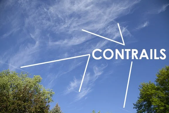
As CONTRAILS spread out and dissipate they can be hidden within clouds. The CONTRAILS in the above photo would be hard to find if you did not know what to look for.
Cirrocumulus clouds can be elusive. They are not a common cloud when compared to more showy middle and low clouds. Cirrocumulus appear small because of their size and great distance above the ground. The examples in the above photo are hidden within the large area of fibratus cirrus clouds. Look closely for the tell-tail sign of a cumulus type cloud - puffy or heaped clouds with blue sky in between the cloud elements.
Cirrus streamers are more appropriately called fall streaks and virga are thinly evident in the photo above. The streaks of ice crystals have precipitated out of the cold air aloft and the ice crystals are being highlighted by sunlight as they fall.
Gravity Waves are a mystery for most people. Adjacent layers of stable air can be set in motions by perturbations in the flow of air. The perturbations form due to wind shear which sets layers in motion vertically and horizontally. The Gravity Waves are not obvious in this photo until you take a close look at the waves in the cloud pattern. Where the air is rising a cloud forms and where it sinks the cloud thins or disappears entirely. The waves look like the waves we see on lakes or in the ocean or rivers. The clouds do not make the waves. The clouds make the waves visible. If they occur in clear air the waves would not be visible. Aircraft can encounter the motion in clear air.
This is not the best example of floccus type clouds - clouds that look like tufts of wool. The cloud also looks like Cirrus uncinus with its curved shape caused by ice crystals falling from a small dense cloud into slower moving air below. This photo also shows a band of Altostratus near the bottom of the image.
Clouds of the Day - Sunday, May 14th 2023
Cloud Identification Answers
Clouds shaped like waves are often observed in the atmosphere. A few examples are found in the photos below which were taken on May 14, 2023 near Fontanelle, Iowa. The waves are are set in motion when air layers become disturbed by the wind. The waves may be invisible but if clouds are present the motion becomes visible. At the top of the waves water vapor condenses to form a cloud. Near the bottom of the wave the cloud thins or disappears. The waves may appear to be stationary or in motion. As the wave pattern moves with the wind the waves also move downstream. Gravity waves may move with, across, or against the prevailing wind creating a variety of cloud patterns.
Lenticularis clouds are lens shaped. There are various different shapes of lenticularis but they all have characteristics that resemble lenses.
Altocumulus are “high” Cumulus. Alto means high so Altocumulus (High Cumulus) are found in the middle layer of the atmosphere (between 6,500 feet/2,000 meters and 20,000 feet/6,000 meters) . Cumulus clouds are found in the low layer of the atmosphere - between the surface and 6,500 feet/2,000 meters).
Stratiformis are clouds in a layer that are much larger in their horizontal dimension than the vertical dimension. Undulatus shapes are caused by wavy motion in the air. Undulatus means undulating clouds. In the photo above we see a broad layer of horizontal cloud with embedded waves impressed on most of the formation. Therefore the cloud is a middle layer cloud with a stratus type formation with undulations impressed on the layer.
Cumulus occur when the surface of the Earth is warmed by the Sun and, in turn, warms the air above. As the air warms it becomes less dense (lighter) than the air around it. The base of a cumulus cloud is often flat, which shows the level where water vapor is cooled by rising and condenses into the cloud. The cloud rises until the temperature of the rising air is the same as the air around it. At that point the rising slows and stops.
The Cumulus above has form in a layer of air that is conditionally unstable. That means, the air will become unstable if it warms enough to rise through the surrounding air. Eventually it cools as it rises to the point that it is not longer lighter than the surrounding air. The Cumulus above are small clouds and have already reached the point where it will no longer rise. The clouds will then gradually dissipate.
The Cumulonimbus below is much larger because the layer of conditionally unstable air is much deeper than the air mass with the Cumulus in the picture above. A Cumulonimbus is producing rain along with lightning and thunder.
Clouds of the Day - Thursday, May 11, 2022
Cloud Identification Answers
Beginners should only use a cloud’s first name. For example, it is correct to name a Cirrus spissatus - Cirrus. Clouds may have as many as three names. Think of it as a first, middle and last names. The Weather Briefing Cloud Identification Chart uses the first and middle name. The additional names further describe how a cloud looks. Click HERE to learn more about clouds and their names.


