Still Waiting
/A large winter storm crossing the West Coast is expected to move eastward through the Rockies into the central U.S. during the next 24 to 48 hours. When the earliest European settlers arrived in Iowa in the 1830s they did not have the luxury of knowing if the weather was going to change. Like the natives they learned to watch the sky, notice the wind, and use weather lore for hints of change. Sometimes the severity of the changes would elude them until it was too late. Today is a great example. Today the weather is very innocent. Clouds have covered the sky much of the day but there is certainly no hint of a big snowstorm on the horizon that would bring great hardship and perhaps death to the unknowing traveler. Temperatures are in the upper 30s and 40s.
The National Weather Service surface weather map shows the associated weather with the western storm. It also shows a generally dry pattern over the central U.S: "The calm before the storm."
Widespread snow is expected through out the west particularly over the mountains and plateau. You can learn the details of local forecasts at www.weather.gov.
Upper level winds at 500 millibars (approximately 18,000 feet) show the upper trough crossing the west coast at 6 a.m. this morning. The trough is the core of cold air aloft. This storm is the real deal as we shall see once it reaches the Plains and feasts on moisture from the Gulf of Mexico.
500 millibar chart courtesy of the National Center for Environmental Prediction. Deep trough is digging southeastward along the west coast.
The map also shows a weak upper level system crossing the Upper Midwest. This system spread light precipitation in the form of rain and snow from Colorado to the Upper Midwest from Saturday into Sunday. The photo below looking north from Cedar Falls, Iowa this afternoon shows the back edge of an altocumulus cloud layer associated with this weak system.
Looking north in Cedar Falls, Iowa at 4:00 p.m. CST. Clearing skies behind weak trough crossing Iowa.
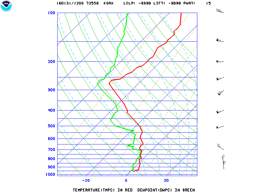
It is interesting to compare the upper air soundings (radiosonde or RAOBs) from Omaha and North Platte, NE this morning. Clouds and precipitation aloft formed ahead of the weak system moving into the Midwest where the air is rising. The RAOB from Omaha shows the moisture in the mid-levels between 800 and 700 millibars, which is a layer between 4,000 to 10,000 feet. Notice how the green dew point line moves closer to the red temperature plot on the chart below. Where the dew point and temperature are close together the relative humidity is high. This marks the area of cloudiness above and east of Omaha this morning.
Radiosonde sounding from NWS at Omaha Valley, NE. Relative Humidity is high where red (temperature) and Green (Dew Point) lines meet.
The next sounding is from North Platte. Notice the atmosphere is drier at same level we looked at over Omaha. The spread between the dew point (green) and temperature (red) is much larger. This is a layer of dry air moving east over Nebraska in an area of downward motion behind the week trough over Iowa and eastern Nebraska. As this dry air moved east today it brought decreasing cloudiness to Iowa allowing the Sun to shine in some places behind the trough.
North Platte sounding shows dry air from just above the surface to about 600 millibars (approximately 13,000 feet).
So what's next? We will watch the western storm move eastward. We expect a surface low to develop east of the Rockies over the Southern Plains before it turns northeastward. A Blizzard Watch covers much of western and northern Iowa into Eastern Nebraska. Around it are Winter Storm Warnings and to the southwest are Blizzard Warnings and Winter Storm Warnings. See the latest at www.weather.gov.
Here is a rather innocent picture looking southeast from Cedar Falls this afternoon. Altocumulus clouds dominate the sky as a weak upper trough moves eastward overhead. We are in the "calm before the storm." I will use this and the previous images as a comparison, before and after the storm. If all goes as planned these scenes will look much different in a couple of days. The difference between now and the mid-1800s is that we know about these storms well in advance. Early settlers and natives did not have that luxury and people paid the ultimate price.
Looking southeast at about 4:00 p.m. CST. Altocumulus cloud deck is moving to the southeast.
Educational hint: Go back to our homepage and scroll down the page until you find the weather code downloads. In the materials available you will find a chart showing all of the weather plotting codes. The wind plots show how to read the wind direction and speed from station model plots. Use the explanation on the chart to read the wind barbs on the upper air map above.


