Summer Heat
/500 MB Chart, 7:00 a.m. CDT, 18 June 2016, from NOAA
A large area of high pressure aloft extends from the Desert Southwest into the middle of the United States this morning. This high pressure aloft (at the 500 millibar level, approximately 18,000 feet) has been responsible for the hot dry weather in the Southwest with readings in the 90s and 80s over the Plains and much of the central and eastern U.S. The hottest weather is occurring under the high pressure center over Arizona, New Mexico northeast to the Central and Southern High Plains. A few thunderstorm clusters, typical of this type of summer pattern, formed in Minnesota, South Dakota, Nebraska, and Kansas. The strongest flow aloft has been forced around the warm air aloft from Northern California into southern and eastern Canada. Scattered thunderstorms are possible today around the northwest and northern edge of the high pressure and also over the Plains. Check your local forecast for details. Cooler temperatures are in the Pacific Northwest and the Great Lakes to New England.
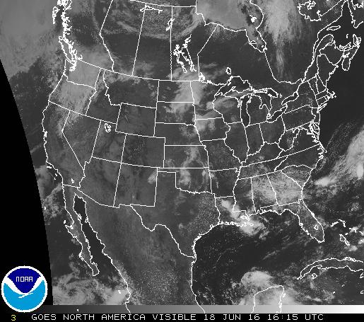
The visible satellite image below from the National Weather Service at 11:15 a.m. CDT shows the remnants of thunderstorms that occurred over the Plains last night and early today. The clouds are mainly middle and high level clouds leftover from rained out thunderstorms. The clouds are located this morning over Iowa, Kansas, and Oklahoma. The cloud band from the Dakotas to western Minnesota is part of a system moving with the stronger SW to NE flow aloft crossing the Dakotas. It contains weakening showers that should dissipate before regenerating this afternoon and evening as it moves over Northern Minnesota, Lake Superior, and into Canada. Thunderstorms are also occurring over Louisiana and northeastern Florida.
Low pressure aloft along the Washington-Oregon coast is creating showers in parts of Washington and Oregon with very spotty activity in the Idaho panhandle and northwestern Montana. As the system moves northeast thunderstorms are likely this afternoon over parts of northern Montana as cooler air aloft rides over warmer and relatively moist low level air.


