Midwest Thunderstorms
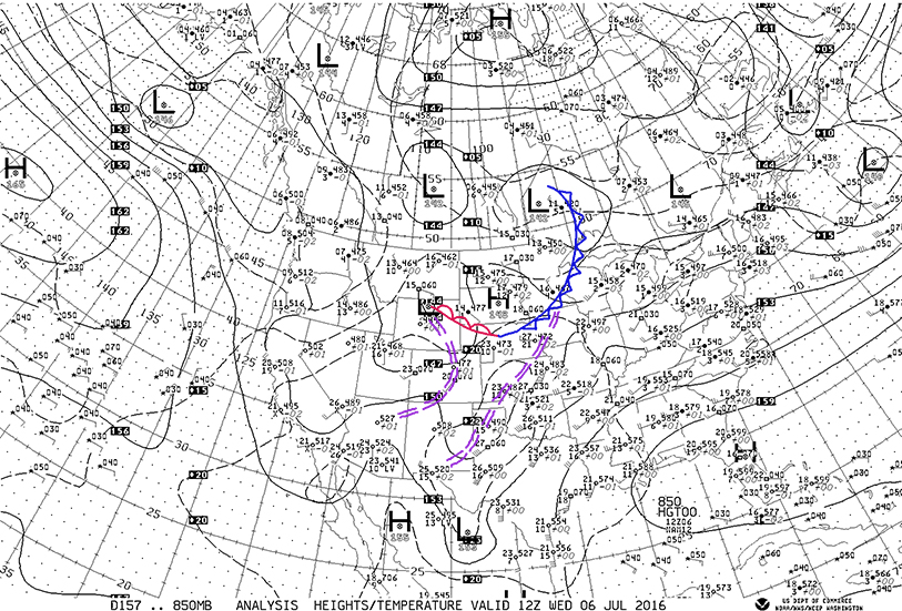
/After a night of thunderstorms in parts of the Midwest more storms are expected today and tonight. The map below shows the upper air flow this morning at 7:00 CDT, Wednesday, July 6, 2016 at 850 millibars (850 mb) which is at about 5000 feet. The map is analyzed for fronts and troughs in the Midwest. An upper cold front (blue) was located from western Ontario through northwestern Wisconsin, southeast Minnesota, northwest Iowa to an upper warm front (red) from western Nebraska into northeastern Wyoming. Upper troughs are located from northcentral Iowa to southeast New Mexico and from Wyoming to Colorado, to northwest Arizona.
There is a general southwest flow of air from western Texas to the Great Lakes and Ohio Valley. A northwest flow is located behind the upper cold front. A southerly flow is getting re-established from western Kansas/Nebraska to the boundary across northern Nebraska, to southeastern Montana. This southerly flow is relatively dry over Nebraska, Colorado, and most of Kansas which will inhibit but not eliminate thunderstorm development this afternoon over the Central Plains. Look for scattered storms to form in the western High Plains as moisture gradually increase.
An interesting feature of the air mass over the Central Midwest is the lack of wide spread deep moisture over the Plains. The upper air sounding from Omaha this morning illustrates the issue. The dashed green line is the dew point while the red line is temperature. On the chart temperature increases to the right and altitude increases upward. Notice how the green line jumps to the left near the bottom - that indicates dry air just off the surface through 10,000 feet.
Notice the northeast winds at the surface (see the right vertical bar) which switch to westerly at about 5000 feet and increase with height. The wide separation of the green and red lines are regions of the driest air.
As southerly flow increases from Kansas to South Dakota pockets of moist air will likely help develop thunderstorms over South Dakota and Wyoming later today and tonight. Thunderstorms should develop north of the boundary that now extends from Wyoming (warm front aloft) to Nebraska (cold front) and move east or southeastward. Increasing moisture over Iowa should allow the storms to grow as they move east or southeastward toward Minnesota and Iowa.
The upper air flow at about 18,000 feet (500 millibars) is shown below. Notice the increasing winds generally from west to east over the northern U.S. and the vigorous low pressure moving through the Pacific Northwest. This is an area of colder air aloft that will spread eastward and destabilize the air over the Upper Midwest Thursday. Look for a major outbreak of severe weather over Iowa as this system moves eastward. For more information on your forecast go to www.weather.gov and also the Storm Prediction Center websites.
Notice the temperatures at 18,000 feet. Davenport, Iowa is -8 degrees centigrade while Great Falls, Montana is -16 centigrade. The strongerflow that will develop at all levels tonight and Thursday will help generate severe thunderstorms across the Upper Midwest starting late this afternoon in southeast Montana, northeast Wyoming, and western South Dakota. The storms should move to the east and southeast with damaging winds and hail and possibly locally heavy rains although the forward motion should somewhat limit flooding except in places where the ground is already soaked. More on this later.


