More Showers and Thunderstorms
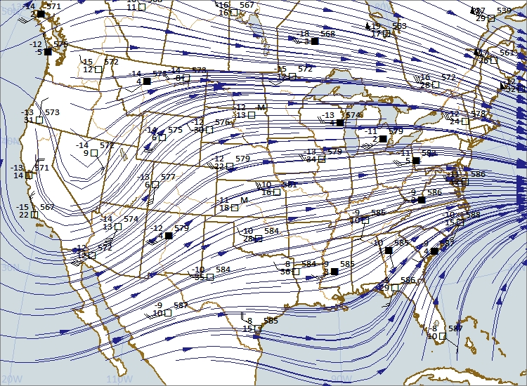
/500 mb chart at 00Z 5-22-2018 (7:00 p.m. CDT 5-21-2018). Chart plotted using Digital Atmosphere software from www.weathergraphics.com.
Weak weather systems dominate most of the central and eastern United States as the next wave crosses the Inter-mountain Region. The storm (trough) aloft extends from Nevada south to just west of Baja Peninsula. The trough is located with the coldest air aloft. The wave dips south over California and turns northeast over Arizona, Utah, Colorado, and New Mexico. As the wave moves east it will increase the chances for more showers and thunderstorms over the central and southern Plains and then east to the prairie states.
Surface Map - 0000Z 22 May 2018 (7:00 p.m. CDT 21 May 2018) Map plotted by Digital Atmosphere available at weathergraphics.com
The two charts above show the relationship between the upper level winds at 18,000 feet and surface winds. A weak surface low is centered near Davenport, Iowa. Another weak area of low pressure is over eastern Colorado with another over Arizona. The Colorado and Arizona low pressures are located ahead of the trough at 500 millibars (18,000 feet) now crossing Nevada south to west of the Baja Peninsula. Look for the low pressure to become better organized east of the Rockies as trough (cold air aloft) emerges over the Plains during the next 24 hours.


