

The Wind has Changed
/
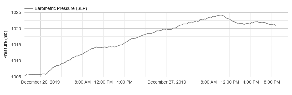
Weather observation at Cedar Falls, IA at 8:30 p.m. CST, Friday, 27 December 2019.
The wind has now turned around to come from the southeast. This is the third of three signs indicating that a storm is brewing. It’s now a matter of just how big. All signs, based on computer model projections suggest a major low pressure system will move from northeastern New Mexico and reorganize over southeastern Colorado before heading toward Iowa and southern Minnesota.
High pressure continues to shift eastward with its center located over southern Lake Michigan. High clouds have spread over northeast Iowa and mid-level clouds have reached southern Iowa. The storm will gather strength as it moves northeast and draws an unseasonably amount of moisture into the system from the Gulf of Mexico.
The map below shows mid-level cloudiness now over southern Iowa, rain, freezing rain and snow in southwestern Nebraska, and rain in Kansas. Notice the C110 (ceiling 11,000 feet) at Ottumwa, C100 (ceiling 10,000 feet at Lamoni, and C90 (ceiling at 9,000 feet) at Omaha, NE. Low level moisture is moving northward from the Gulf of Mexico with surface dew points in the 40s and 50s over Oklahoma and Texas and 50s and low 60s in Arkansas. This moisture will be lifted as it moves north over colder air setting the stage for wide spread rain and thunderstorms in the warm air east and south of the low center track with a large area of moderate to heavy snow expected to develop to the left of the low center path.

Meanwhile the pressure continues to drift lower at Cedar Falls in northeast Iowa. The rate of pressure fall will accelerate once the low organizes over southeast Colorado and moves over the Southern Plains toward Iowa. The weather will get more interesting by the hour overnight into Saturday.
If you are not familiar with the station model plots shown on the map above go to the Station Model Plot explanation found on this website HERE. Just scroll down until you come to the station model section.
What’s coming next? Temperatures over Iowa will remain steady or rise slowly tonight into the day on Saturday. Rain will spread into western and northern before dawn with some ice accumulation where readings stay below freezing. The low center should become established over southeastern Nebraska during the night and begin moving east then northeast into Kansas toward Iowa. Pressures will continue to fall ahead of the low center. Cloud ceilings will lower over Iowa and points southwest as the precipitation shield advances to the northeast.