Clouds of the Day - May 3, 2020
/Waves in the air.
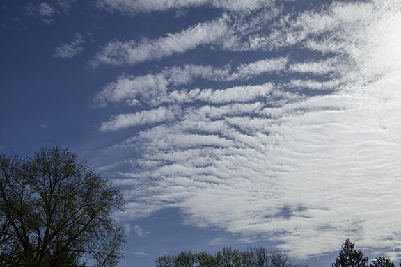
When we looks at clouds we often wave patterns. Many, but not all, of the photos below are of clouds that look like waves. They are called gravity waves. Look at each photo carefully and see if you can spot the waves. Some of the photos have waves superimposed on on other waves. Don’t forget to look closely! An eye for detail will be rewarded by seeing multiple waves of different sizes in the same photo.
Gravity waves are set up by air motions of different speed and direction embedded within adjacent layers. They layers ripple much like waves in the ocean. Clouds make the waves visible. Gravity waves are also caused by up, down, and horizontal motions in and around thunderstorms or air crossing mountain ranges. The air oscillates up and down and side to side. If moisture is sufficient clouds form where air is rising with clearing where the air descends. Look at the photos below and see if you are able to find waves. Hint: Not all of the photos have waves.
This chaotic looking sky includes several cloud types. The primary types are altocumulus which are front and center, cirrus which are visible at a higher altitude and plainly visible in the upper right of the photo, altocumulus upper left, and altocumulus and probably altostratus lower left.
This photo has multiple types of altocumulus spread over the entire frame.
Here we have several types of altocumulus again. The altocumulus in the upper left have a very distinct puffy cumulus structure while other stratocumulus in the lower center have a more layered look so there is both a stratus and cumulus structure with waves and cells that put them in the altocumulus category.
This is the same part of the sky but with the photo moved more to the left. The couds are almost entire altocumulus of different varieties but look closely and you will see a thin cirrostratus layer visible behind the altocumulus on the right and lower part of the photo. This is cirrostratus.
Look closely at this photo for many clouds of different sizes and shapes. There are both altocumulus and altostratus. The altocumulus are wave type clouds although there are some very small individual cells visible in the lower left and also i the upper left quarter. The altostratus are visible as smooth layer type clouds. THere are waves in varying sizes across the entire photo.
If these clouds make you think of waves on a lake or the ocean - they should! The atmosphere is undulating in a stable layer so the clouds don’t grow with height. THere is a wide separationg in the waves. Look at other clouds in today’s photos and you will see many waves of different sizes. Did you notice the condensation trail (contrail) in this photo? It is from an aircraft flying much higher than these clouds.
MOre wave type altocumulus. THere is also an altostratus layer on the right that is “imipressed” with waves.
THis photo is rich with complex cloud structures. These structures reveal a varitey of atmopsheric motions this morning. There are altocumulus all over this photo. Notice the larger waves across the top, small cells in the upper right, a combination of cells and waves across the bottom. THere are altostratus across the middle with embedded cumulus cells and scattered wave structures.
Altocumulus
Altocumulus
Altocumulus with a mix of altocumulus and altostratus lower left. Notice the faint streak of white covering part of the lower left altocumulus near the trees. It is falling ice crystals trailing from the dense altocumulus in the upper left of center.
Cellular and wave form altocumulus
Altocumulus and altostratus
Altocumulus and altostratus
Wave form altocumulus with altostratus that have faint wavies.
Cirrus
Altocumulus and altostratus
Cirrus and cirrostratus with patches of altocumulus/altostratus
Cirrus upper right with dense sirrus center and alto stratus lower left
Cumulus
The photos were taken in chronological order between 10:00 a.m. and 5:00 p.m.


