Clouds of the Day - Sunday, December 26, 2021
/Altocumulus and Altostratus
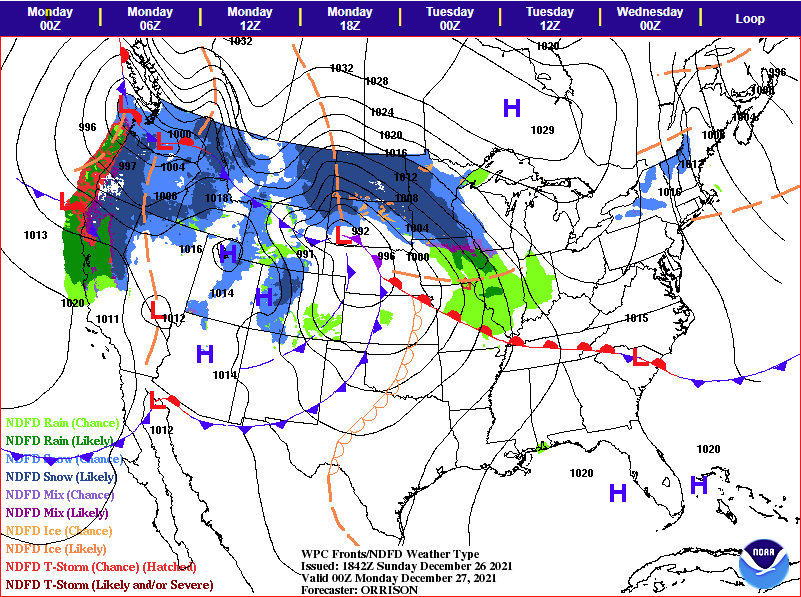
A low pressure system is organizing over western South Dakota today. The forecast map below shows the expected position for fronts and precipitation at 6:00 p.m. this evening. Clouds have been overspreading Iowa today and ceilings are expected to continue to lower this afternoon. Three photos below show the mid-level cloud types that have been visible so far as the storm system expands upward motion eastward.
Forecast Map from NOAA/Weather Prediction Center valid 6:pm CST 12-26-2021
Wave Clouds - Altocumulus with altostratus above
Wave Clouds - Altocumulus with altostratus above
Left above - Upward air motion is causing water vapor to condense into mid-level clouds. Waves in the air flow are rippling through the cloud layer to form these wave clouds - altocumulus. Altostratus are visible above the altocumulus layer.
Right above is another view of the altocumulus looking to the southeast. The flow at the cloud level is from the northwest so this photo looks down stream with the flow. Altstratus is visible above the altocumulus.
The left photo above looks to the north and shows altocumulus lined up in rows from southwest to northeast and as individual cloud elements.
The right photo is looking west in the early afternoon and shows mostly altostratus clouds. However, there are still ripples of altocumulus waves apparent in the bottom and lower right corner. These photos show the broad scale of the upward motion and the mid-level clouds that have formed in the area of upward motion. The clouds cover northeast Iowa will continue to lower as moisture increases within the area of broad upward vertical motions. The expected sequence is for the altostratus to invade the entire sky followed by precipitation aloft obscuring the cloud ceiling. Once the precipitation reaches the ground the cloud will be named nimbostratus. The precipitation will be rain. The temperature as I post this text is 41 degrees how the precipitation will begin as rain and snow aloft, but the snow will melt before reaching the ground.


