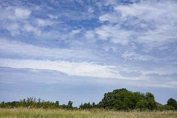
Clouds of the Day - June 30, 2022 - Mid-Level Cumulus and Stratus
/I am posting five photos today. The first two were taken at Noon, looking northwest from Cedar Falls, Iowa. The last three were taken in the mid-afternoon. The first two photos show two principle cloud types; cumulus and stratus.
The clouds are in the middle level of the atmosphere (between 6,500 ft and 20,000 ft). The principal cloud types in the mid-levels use the prefix ‘alto’ so they are altocumulus or altostratus. The prefix alto means ‘high’ so these clouds are high cumulus and high stratus when compared to lower cumulus and stratus found below 6,500 ft.
Some of the cumulus are separated by small areas of blue sky. Others are in a thin layer that includes waves or ripples. Near the top of the photo the cumulus are larger and are individual cells rather than part of a continuous layer. Near the bottom of the photo the clouds are stratus; a smooth layer without ripples.
What can we conclude from this photo?The air is more unstable (deeper upward and downward motion) in the upper half of the photo. It is more stable in a shallow layer that is smooth in the bottom half of the photo. The upward motion is stronger where the clouds are larger lumps with blue sky in between. The flat layered clouds form in a broader area of gentler upward motion.
The last three photos show different views of altocumulus clouds. The cloud cells look much small than the altocumulus in the first and second photos because they are much higher. The size of cloud elements help us estimate cloud height (low, middle, or high) but it can sometimes be tricky. Estimating height comes with experience with cloud size and the location of other clouds helping to make the estimate.
Photo by Craig Johnson, Weather Briefing, LC. 12:00 p.m. CDT looking northwest of Cedar Falls, Iowa. Cloud description in the text of this post.
Photo by Craig Johnson, Weather Briefing, LC. Close-up of photo above taken at 12:00 p.m. CDT. Clouds in this photo are primarily altocumulus with altostratus variety in the lower 20% of photo.
Altocumulus Photo Looking NE from Cedar Falls, Iowa by Craig Johnson, Weather Briefing, LC
Altocumulus photo looking ENE from Cedar Falls, IA by Craig Johnson, Weather Briefing, LC
Altocumulus and Altostratus Photo looking southeast from Cedar Falls, IA by Craig Johnson, Weather Briefing, LC
Here is the surface map as of 18Z (1:00 pm CDT). Low pressure in Utah and Wyoming will be moving eastward today and tonight. The clouds in the above photos are forming ahead of that front in a southwesterly surface flow. Automated weather stations at Waterloo, Iowa and other locations are not indicating clouds because automated stations do not measure cloud ceilings above 12,000 feet. Locations such as Mason City, Fort Dodge, and Sioux City in Iowa are plotting clear skies. Des Moines, Iowa and Omaha, Nebraska plot ceilings of 25,000 feet (C250). Those ceilings are estimated by human observers. The photos above show clouds in the Waterloo/Cedar Falls area.
As the low pressure tracks eastward moisture, warmer temperatures, and lift are expected to increase over the region with thunderstorms expected to develop later today, tonight and into Friday. Check your local forecast to see what is expected if you live in this area of the central United States west to the Rockies. On our home page click on the National Weather Service for your forecast.
Map plotted by Digital Atmosphere. The software is available at www.weathergraphics.com.


