Clouds of the Day - An Eastern Exit
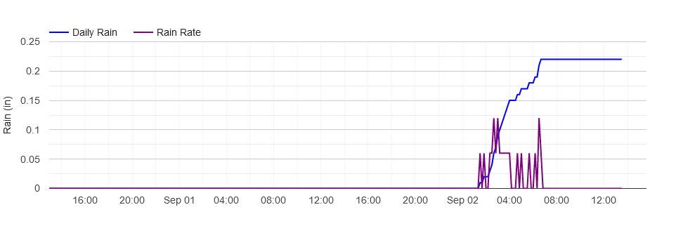
/As the Sun was rising this morning clouds from nighttime showers were making an eastward exit. Our weather station rain guage measured .22 inches of rain overnight. The graph below shows when the rain began and ended. You can see the rain began after 1:00 AM and ended before 7:00 AM. The live chart on our website is interactive and allows you to see the time and amount of the rain. The accumulation of rain is the blue line and the purple is the rainfall rate per hour.
The wide angle photo shows faint crepuscular rays left of center. It also shows a variety of clouds on the backside of the exiting storm system.
The sky at the back of a storm system can be chaotic. There are several middle level cloud types in this photo. Photo by Craig Johnson at Cedar Falls, Iowa. Copyright 9-2-2022.
Close-up of the wide angle photo. Copyright Craig Johnson, Weather Briefing L.C. 9-2-2022.
A close-up of the clouds show some interesting patterns. In the center are altocumulus stratiformis lacunosus clouds. This is the complete scientific name including the - principle cloud type name , species, and variety names of the cloud.
Altocumulus is the principal cloud name, stratiformis is the species name, and lacunosus is the variety name. Altocumulus means high cumulus; it is higher than the regular low level cumulus cloud but below the cirrocumulus level. Stratiformis means the cloud is in a layer with stratus and cumulus characteristics, and lacunosus refers the the many holes in the cloud layer.
Toward the bottom there are altocumulus stratiformis clouds. They are lower than the layer highest clouds but higher than the lowest layer below. They cover the clouds above and have elements of small lumps mixed in a flat cloud layer.
Finally, the lowest clouds are altocumulus lenticularis - wave clouds at the bottom left and bottom right of the photo. The waves are rippling through the flow and are also visible at the far right of the wide angle photo.


