

CONTRAILS and Clouds: 2-26-2023
/Here is the forecast map for today from the Weather Prediction Center based on input from the Storm Prediction Center and National Hurricane Center. It is valid 7:00 a.m. this morning through 7:00 a.m. Monday, 27 February 2023. All three of those weather centers are associated with NOAA and are linked to from the Weather Briefing Homepage.

During the period snow and mixed precipitation is expected over northern New England, rain and freezing rain over the Upper Midwest with rain from the Mid-Mississippi and lower Missouri River valley to the Southern Plains where severe storms are possible. Much of the mountain west is expecting snow with rain in lower elevations with widespread rain expected over the far west including the West Coastal areas. Check your local NWS forecast which is also linked to on the Weather Briefing Homepage.
The photos below were taken this afternoon from Cedar Falls, Iowa. Rain is not expected here until later tonight so what you are seeing is rather deceiving. As the storm approaches clouds will thicken and lower but at the moment we are experiencing plenty of sunshine with our temperature near 50 degrees. See our weather station observation on the Weather Briefing homepage for the latest conditions.

This photo looks south. Cirrus clouds are streaming in bands from west to east. A CONTRAIL is visible left of center. It is water vapor condensing in the engine exhaust into the cold upper air. Winds aloft at the cirrus level are estimated to be around 50 - 55 mph and at the altitude of the aircraft probably closer to 75 mph from the west.
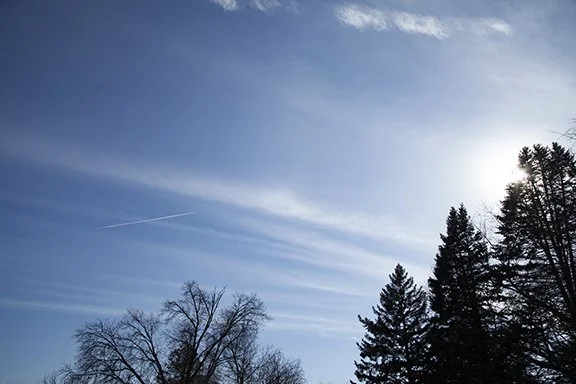
This is a closer view showing the CONTRAIL, Sun, and the Cirrus clouds. The cloud types are Cirrus fibratus and cirrostratus and the CONtRAIL.
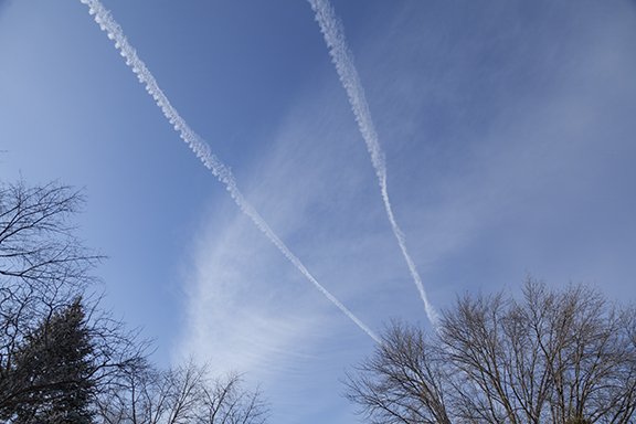
Two parallel CONTRAILS are above the cirrus clouds. These cirrus are likely caused by the spreading out of an old CONTRAIL.

More contrails. This view is looking south and South southeast and were freshly formed. Another contrail is visible near the bottom of the photo. There is a closer view if you scroll down.

These contrails appear to be below the clouds. Other parts of the same CONTRAILS are above the clouds.

This patch of cloud appears to be made by the spreading of several CONTRAILS. Notice the fibraus cirrus in bands that are perpendicular to the thicker contrails. Air is moving parallel to the main cloud band and the ribs, which are perpendicular to the denser cloud band, is caused by descending air where the air is relatively clear and rising where the thicker bands (ribs) are visible.

The contrail across the bottom of the photo is breaking into a series of helmholz waves. You will get a better look in the photo below.

Notice the waves in the remnants of this CONTRAIL. Helmholz wave clouds are also known as fluctus. The cloud tops are leaning to the left because of stronger winds at the top than at the bottom of the cloud. This is called wind shear and occurs when winds increase with height in a stable layer of air. Stable air limits vertical motions in the layer. The winds are blowing from right to left. The waves make the air motion visible. It is likely that much of the sky is experiencing