

Clouds of the Day - Saturday, March 25, 2023
/Saturday, March 25, 2023 has been mostly sunny in Cedar Falls, Iowa with mainly cirrus and altocumulus clouds overhead. The day started with about 80% cloud cover but it is down to about 20% now with mostly thin cirrus.
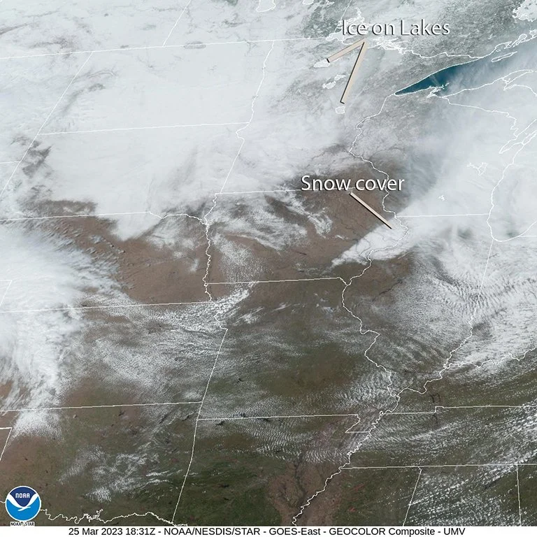
Low pressure centered over lower Michigan this morning is moving east. It left a strip of snow on the ground which is visible in the satellite image below. Cooler air is spreading south and southwest over the Northern Plains and Upper Midwest. This is evident in the temperatures which are in the 20s over North Dakota to the 30s in South Dakota, and 40s over Minnesota and Iowa. Decode the station model plots in those states to the the dew point and temperature readings. The winds on the station model plots are from the northwest through northeast at about 10-15 mph around the backside of the Michigan low pressure center.
Moderate to heavy snow is falling over the mountains of northern Wyoming and southern Montana and along the eastern upslope of the Rockies in Montana.

Map Plotted with Digital Atmosphere Software available from www.weathergraphics.com
Gulf Moisture is spreading northeast into the southeast U.S. with dew points in the 50s, 60s, and 70s.
I purposely used a moderately spaced distribution in the station model plot on this map to make it more readable than a denser plot. This would be a good map to practice your station decoding skills. Check out the station model plot tutorial part of our website for more details on the plots.
Clouds of the Day - Cedar Falls, Iowa

Photo copyright 2023 by Craig Johnson, Weather Briefing, LC.
This photo shows a large area of several cirrus cloud types this morning. The clouds were moving to the southeast from the upper right to the lower left. The clouds in the lower right half of the photo are mostly cirrus fibratus with more dense patches of cirrus mixed in. The striations are parallel to the wind direction.
In the upper left half there is more evidence of cross-banding of wave clouds perpendicular to the wind direction. There is also more instability present in three or four bands of cirrus in dense patches. These are cirrus spissatus with falling ice crystals trailing each dense cloud cell. This is precipitation aloft. There is a large area of fall streaks with intertwined fibers in the upper left area of the photo. There are CONTRAILS mixed in with the cirrus which are likely causing some of the the dense spissatus type cells to form.
This photo looks south.

Photo copyright 2023 by Craig Johnson, Weather Briefing, LC.
This is a look at the same part of the sky as the photo above but it is centered more to the upper right. The same discussion applies. Natural cirrus is mixed with clouds forming from the CONTRAILS. This creates a chaotic look to the clouds.
This photo looks south-southeast.

Photo copyright 2023 by Craig Johnson, Weather Briefing, LC.
Further northwest is a less developed area of cirrus. There are four well defined CONTRAILS in different stages of development. The youngest CONTRAIL is in the left center of the the photo. Each CONTRAIL to the upper right is progressively older than the one below it. It is easy to see how the CONTRAILs are changing with time by looking at the progression as the CONTRAILS age. This photo looks west.

The first three photos from the top were taken around 9:00 a.m. this morning. The photo above was taken about three hours later. It shows more CONTRAILS and the remnants of CONTRAILS. The natural cloud formations are the banded striations in the clouds on the far right center just above the trees and also the dense cloud patch along the bottom 1/4 of the photo. Everything else is related to CONTRAILS. By the way, CONTRAIL is an acronym for Condensation Trail which is condensing water vapor in the exhaust of aircraft flying around 20,000 to 40,000 feet above sea level.