Stratocumulus - One Sign of Winter

Surface Map, 1200Z (7:00 a.m. CDT) October 11, 2019, Map plotted by Digital Atmosphere, Weathergraphics.com; The solid lines are isobars (lines with the same atmospheric pressure. The low center is near lake Superior. The narrow spacing between the …

Surface Map, 1200Z (7:00 a.m. CDT) October 11, 2019, Map plotted by Digital Atmosphere, Weathergraphics.com; The solid lines are isobars (lines with the same atmospheric pressure. The low center is near lake Superior. The narrow spacing between the isobars indicates a tight pressure gradient over Iowa which causes strong winds. It was a windy day with stratocumulus.

Cold air sweeping in behind a low pressure center often forms stratocumulus clouds over Iowa. The clouds form as the colder air converges into the center of low pressure to the northeast. As low level air converges it rises to the top of the cold air where it meets sinking air from above. The sinking air is warming as it descends and creates a boundary when it meets the rising air below. Along the boundary is where the stratocumulus form. There is just enough instability and moisture in the colder air to create rising air and clouds as you see in the photo below. The clouds have the look of cumulus with rounded bottoms and tops but at the same time the entire layer looks like a sheet of stratus. The name is stratocumulus. Strato for the sheet or layered structure of the entire cloud sheet and cumulus for the rounded form of the individual cloud elements.

Stratocumulus over Adair County, Iowa. Photo by Craig Johnson 10-11-2019

Stratocumulus over Adair County, Iowa. Photo by Craig Johnson 10-11-2019

Iowa is located close enough to the Great Lakes that storm systems moving northeast out of the state move over the waters of the lakes - usually Lake Superior and northern Lake Michigan. When the air mass behind the storm is colder than the lake water temperature the low pressure center may intensify. Intensification causes the circulation around the low to increase and contributes to low level moisture circling around the storm. The result? Stratocumulus.

Of course this does not always mean winter is coming because this phenomenon is common around the Great Lakes in other seasons - namely spring and fall. But this time of year stratocumulus with strong northwest winds after a storm us usually a sign of a change of seasons. Iowa is just close enough to get in on the action. Eastern Iowa feels this effect more often than the southwestern counties but in this case the clouds formed across the entire state, including Adair County.

2 Hours in the Life of the Prairie Sky on Friday, October 18, 2019

Heading to winter means big changes overhead. Sometimes they happen quickly. Let’s look at a 2 hour “snapshot” of the sky over northeast Iowa last Friday. The following images are photos taken Friday afternoon, October 18, 2019. The photos show the variety of cloud formations that appeared in a matter of two hours. The sky came alive as clouds changed shape and texture almost minute-by-minute.

Most of the United States resides under the Westerlies. The Westerlies is a west to east river of air found between 30 and 60 degrees north latitude. (For those living in the Southern Hemisphere you have your own westerlies between 30 and 60 degrees south latitude.). During the summer the core of the Westerlies is found near the United States - Canada border. It extends around the entire hemisphere at roughly the same latitude.). The Westerlies are weak during the summer with wind speeds at about 30,000 feet ranging between 20 and 70 mph. During the winter the Westerlies drop south, often flowing across the southwest United States to the region from the Carolinas to northern Florida. The speeds in the core reach often exceed 100 mph and can top 150 mph.

Why does this matter? The westerlies carry storms and fair weather around the hemisphere. As the winds aloft become more energetic during fall, clouds change dramatically! The photos below show some unusual shapes and patterns that formed and dissapated in a few tens of minutes. Check them out and if you live under the westerlies look for rapid weather changes as winter approaches. Temperature will rise and fall during autumn but the over-all trend will be down.

Cirrus and altocumulus, Cedar Falls, Iowa. Photo by Craig Johnson

Cirrus and altocumulus, Cedar Falls, Iowa. Photo by Craig Johnson

Looking at the same clouds A few minutes later. Same The clouds have moved to the right. Photo by Craig Johnson

Looking at the same clouds A few minutes later. Same The clouds have moved to the right. Photo by Craig Johnson

More altocumlus. Photo by Craig Johnson

More altocumlus. Photo by Craig Johnson

Cirrus streamers with different textures. Photo by Craig Johnson

Cirrus streamers with different textures. Photo by Craig Johnson

Cirrocumjlus, Cirrus fibratus, and altocumulus, Photo by craig Johnson. Notice the cloud patterns.

Cirrocumjlus, Cirrus fibratus, and altocumulus, Photo by craig Johnson. Notice the cloud patterns.

Cirrus again. Notice the banding. This formation has both Cirrus fibrates and Cirrus uncinus. Photo by Craig Johnson.

Cirrus again. Notice the banding. This formation has both Cirrus fibrates and Cirrus uncinus. Photo by Craig Johnson.

Altocumulus cumulogenitus

Photo by Craig Johnson, Copyright 9-28-2019, Fort Dodge, Iowa

Photo by Craig Johnson, Copyright 9-28-2019, Fort Dodge, Iowa

Flying high over the Des Moines River Valley were two patches of Altocumulus cumulogenitus. Virga trails can be seen falling and streaming behind the clouds. These clouds are high based convection with drier air below. The precipitation is not reaching the ground. The cloud tops have reached a stable layer which has stopped their growth.

The photo is taken at the remains of the Hydroelectric Dam on the Des Moines River in Fort Dodge. Once source says the dam was built in 1916 while another places completion in 1922. In any case the dam provided electricity for downtown street lights until 1971. There were five gates with a spillway that extended left in the photo to the other side of the river. The dam height was 16 or 17 feet with a length of 366 feet. Only part of the skeletal structure of the building remains with one gate chute in place. The remaining gate does not function.

Cumulus in Layers

P:hoto by Craig Johnson, 9-28-2019, Near Williams, Iowa

P:hoto by Craig Johnson, 9-28-2019, Near Williams, Iowa

This photo was taken on the Iowa prairie near Williams. High overhead are altocumulus clouds. Below are newly forming cumulus. While both layers feature cumulus clouds the processes creating the clouds are quite different.

The higher clouds are formed by the advection (horizontal movement) of moist air between 8,000 - 10,000 feet. The moist air begins to rise in cells, which form clumps of cloud. If you look closely you will also see parallel lines of cloud waves in the layer. Where the motion is upward, cloud forms. Where air is clear the air is sinking.

Down below we see evidence of a different process. The rising Sun is heating the ground, which in turn is heating the air. As the air warms it rises, forming cloud cells that look much like cotton balls. Air is rising in columns creating the puffy clouds. Where it is not rising the air remains clear.

The clouds are all in the cumulus family. Cumulus means “heaped” in Latin. Heaped clouds that form in the low levels are called cumulus. If they form at higher levels they are altocumulus, meaning high cumulus. The highest cumulus are called cirrocumulus because they form at the cirrus level.

Cirrocumulus lacunosis Clouds

Cirrus lacunosis, photo by Craig Johnson at Cedar Falls, Iowa

Cirrus lacunosis, photo by Craig Johnson at Cedar Falls, Iowa

This is not a common everyday run-of-the-mill cloud. On the other hand they appear often enough that you should be on the look-out for them. Look past the lower cumulus clouds and you will see cirrocumulus lacunosis. The definition from the World Meteorological Organization states, “Cloud patches, sheets or layers, usually rather thin, marked by more or less regularly distributed round holes, many of them with fringed edges. Cloud elements and clear spaces are often arranged in a manner suggesting a net or a honeycomb.”

This cloud type is most often found at the cirrus level but can also be seen as a type of altocumulus and rarely a stratocumulus. The lacunosis in this photo are at the cirrus level. They have irregular edges with holes in the middle. The lower clouds are cumulus. Lacunosis often have a honeycomb shape. This cloud type forms when a layer of cool air mixes with a higher warmer layer in the atmosphere. When at the cirrus level the layers of air are only relatively warm and cold. Temperatures, even in the summer are below freezing.

Photo Copyright by Craig Johnson, Cedar Falls , Iowa 9-2-2019

Photo Copyright by Craig Johnson, Cedar Falls , Iowa 9-2-2019

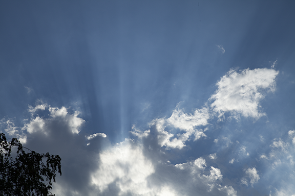
Crepuscular rays are attention-getters. The shafts of light are created when sunlight passing through the air is scattered by dust and other small particles. The darker bands are simply shadows caused by light encountering clouds. The cloud shadows provide contrast between light scattered by particles in the air and the darker shadow bands.

Weird, huh?

Photo by Craig Johnson, September 2, 2019, Cedar Falls, Iowa

Photo by Craig Johnson, September 2, 2019, Cedar Falls, Iowa

Weird, huh? Maybe not as weird as it appears. To begin, these are altocumulus. Altocumulus are a mid-level cloud found between 6,000 feet and 18,000 feet with a cumulus (puffy) structure. These altocumulus are also a type of wave cloud. There are waves moving from the bottom to the tip of the photo and from left to right. The crest of each wave (upward motion) forms a cloud while valleys (downward motion) create blue sky.

Weather involves processes that occur on a range of scales from large to small. Looking at this photo, notice 3 main bands of waves extending from left to right while moving from the bottom to the top. At the same time, within each wave, smaller cloud bands are lined up from left to right. It looks like there are large waves moving from the bottom to the top of this photo and smaller waves moving from left to right across each large cloud band. For example, the middle band has left to right oriented waves on the left and smaller waves on the right. The smaller waves feather out into the blue sky.

Most people glance at the sky. Try spending time looking closer. Watch how the clouds move and notice how their shapes change. See if you can identify the basic cloud types: puffy (cumulus), layered (stratus), and hair-like (cirrus).

Internal Lighting

Photo by Craig Johnson - September 2, 2019, Cedar Falls, Iowa

Photo by Craig Johnson - September 2, 2019, Cedar Falls, Iowa

This is an example of the setting Sun creating special effects. We were out sitting on our deck enjoying dinner and watching clouds drift slowly overhead. The clouds were cumulus mediocris (medium size cumulus). The coloration was due to the changing color of the light as the Sun dropped lower in the sky. As the clouds approached they were non-descript - just white with a few shadows. But just as they began to pass, this view appeared, lasting only a couple of minutes. It’s a good example of how the right kind of lighting will enhance an ordinary cloud formation, if only for a few minutes. You need camera in hand because unlike portrait photograph, under controlled lighting, this cloud “posed” briefly before moving on. The back lighting lasted only briefly.

Bathed in Red

Photo by Craig Johnson - August 2019, Cedar Falls, Iowa

Photo by Craig Johnson - August 2019, Cedar Falls, Iowa

A hint of yellow, plenty of red, and a layer of cirrostratus set up a spectacular sunrise. Rays from the rising Sun were reflected off the cloud bottom to create a brilliant reddish hue. Sunlight contains the full spectrum of visible light but when the Sun is near the horizon most of the shorter wavelengths of light are backscattered by ice crystals in cirrus clouds. Found above 16,000 feet, blue, green and everything in between are filtered out leaving yellow and red light. As the Sun climbed above the cloud layer the red and yellow disappeared leaving a distinct white layer of cirrostratus.

Altocumulus and altostratus

Photo by Craig Johnson - August 2019, Cedar Falls Iowa

Photo by Craig Johnson - August 2019, Cedar Falls Iowa

Another day and another sunrise looking the same direction as the photo above. This time sunlight was shining on a midlevel cloud at about 12,000 feet seen above darker lower clouds. The lower clouds were also in the mid-layer at around 6,000 feet above the ground. The mid-layer is defined as clouds between 6,000 feet and 18,000 feet, which is over 2 miles thick - easily enough room to have multiple cloud layers. The darker clouds are altostratus and altocumulus.

Cumulus under altocumulus

Photo by Craig Johnson - August 2019

Photo by Craig Johnson - August 2019

There are two cloud layers in this photo. The lowest contains cumulus clouds which are below 6,000 feet. The upper layer is altocumulus - a middle layer cloud found above 6,000 feet but below 18,000 feet. Both cloud types form individual cells. the cells are made up of a core of rising air where water vapor has become visible due to condensation. These clouds are entirely separate from each other. The air around these cumulus is sinking as the air in the cloud is rising. The mid-level clouds are also cells of rising air surrounded by sinking air but the cells are closer together. The mid-level clouds resemble more of a layer cloud while still featuring the cell structure of cumulus. Cumulus in the lower layer are called “cumulus” but when they form in the middle layer are referred to altocumulus (high cumulus).

Photo by Craig Johnson - August 2019

Photo by Craig Johnson - August 2019

This is a view of a cumulus from the bottom. Cumulus usually have flat, or nearly flat, bases. That’s because as air rises it reaches the condensation level. That level is often very consistent so the condensation occurs at the same height. It is also possible for condensation to occur at different levels in the same cloud. In that case the clouds have a ragged bottom. This cumulus did not have a distinctly flat bottom. In general, it was flat but there were variations in the level of condensation. From this angle it is possible to see the ragged cloud edge and the varying thickness of the cloud caused parts of the base to be brighter or darker than other parts.

Cumulus Mediocris

Cumulus mediocris, Photo by Craig Johnson, Copyright July 2019

Cumulus mediocris, Photo by Craig Johnson, Copyright July 2019

Cumulus mediocris - a medium size cumulus. This cloud, and several others of similar dimension, turned the sky into a three dimensional extravaganza. The dark base and subtle shading at its top caused the cloud to “pop” out of the deep blue sky. It’s almost as if we could touch the cloud or bounce up and down like on feather-soft pillow. This cumulus mediocris drifted across the sky and slowly evaporated as new cumulus formed.

Cumulus commonly form during the warmth of the day. They are most common in summer when heated air, warmer than surrounding air rises. To see this principle in action watch hot air balloons rise. As the balloon rises the air inside cools, eventually becoming cooler than the surrounding air. The balloon then begins to sink. The pilot must add more heat to cause the balloon to rise again or it will eventually sink to the ground.

A cumulus mediocris does not have the luxury of having a pilot add more heat. Instead, if the air in the cloud does not remain warmer than the surrounding air it sinks and the cloud evaporates.

So how do cumulus clouds keep rising? As the cloud rises water vapor in the air condenses, releasing heat into the cloud. As long as the heat released into the cloud keeps it warmer than the surrounding air the cloud grows. Sometimes a cumulus mediocris grows into a thunderstorm - called a cumulonimbus. The cloud in the picture above did not grow larger. It became cooler than the surround air and began to descend and evaporate.

It turns out that cloud formation, size, shape, and growth are determined by several factors. Something must lift the air. There must be enough water vapor in the air to condense into a cloud. The temperature difference between the growing cloud and its surroundings determines the height of the cloud. And the wind shapes the cloud. In the end all of those factors determine if rain, snow, or hail fall from the cloud.

On this day nothing fell from the cloud. It simply grew to the height you see in the photo and then evaporated - disappearing into thin air!

Looking Down the Line

Shelf Cloud Blow Through Cedar FAlls, Iowa, Photo by Craig Johnson, Copyright 2019

Shelf Cloud Blow Through Cedar FAlls, Iowa, Photo by Craig Johnson, Copyright 2019

Shelf clouds are among the most impressive on the planet. This one looked worse than it was. Forming on the boundary between warm moist air ahead of a thunderstorms and cooler air rushing out of the advancing storm, shelf clouds look scary! This one passed harmlessly overhead. Scroll down for more images of this and other shelf clouds.

Painted Sky

Photo  by Craig Johnson, Cedar Falls, Iowa, USA. Copyright August, 18, 2019.

Photo by Craig Johnson, Cedar Falls, Iowa, USA. Copyright August, 18, 2019.

Enjoy this photo of nature’s handy-work. While the sky was smeared with ice crystals temperatures on the ground were in the lower 80s. The clouds in this photo are called cirrus. The name comes from Latin meaning “hair-like.” The strands in this photo certainly look like flowing hair.

Ice crystals do not evaporate - they sublimate. That means the ice changes directly from ice into water vapor without first becoming a liquid. Evaporation occurs when water changes into water vapor. Sublimation is slower than evaporation so the cloud edges are easily blown into streamers by winds aloft. It is the slowly sublimating ice crystals that make this effect possible.

Altocumulus Sunrise

The morning of August 10, 2019 dawned with the eastern sky full of backlit altocumulus. The contrast between light and dark was dramatic. Notice the cumulus elements in the midlevel cloud layer. Some are very small while others are larger and more dense. The dark cloud bases show where clouds are thickest. Altocumulus indicate instability in the middle levels of the atmosphere.

The second photo below shows the eastern sky a few minutes later. Clouds had receded eastward, meaning the layer was now lower in the sky. A hint of blue near the top of the frame shows what was coming for the day. In this case the cloud layer was created by an upper level disturbance (region of cooler air aloft) that crossed Iowa. Upward motion with the system released the instability causing the altocumulus to form. Lower clouds did not form because the upward motion and moisture was only sufficient above 6000 feet for cloud formation.

Think about air motion in terms of up and down and sideways. The sideways motion (horizontal) is generally stronger than the up and down motion. We call horizontal motion “wind.” When up and down motion becomes strong we often end up with thunderstorms - cumulonimbus clouds. This was not a thunderstorm day for us.

_MG_7009_8-10-2019-WEB.jpg
_MG_7010_8-10-2019_WEB.jpg

Shelf Cloud (Arcus) Approaching Cedar Falls, Iowa

Shelf clouds are one of two types of arcus clouds that sometimes form on the leading edge of thunderstorms. The other type is the Roll Cloud. Arcus clouds mark the leading edge of cool air descending from the storm. The cooler air plows into warm air flowing into the storm. This shelf cloud approached Cedar Falls, Iowa just before Noon on Wednesday, July 17th. Wind speeds at the surface often reach 40 to 70 mph with extreme speeds over 100 mph possible. However, in this case winds were less than 40 mph and there was no damage reported.

Underneath the Anvil

IMG_0156_3x4_Anvil_WEB.jpg

Photo Copyright 2019 by Weather Briefing, LLC

This is not a bad place to be - for the moment. The bottom of a thunderstorm is located in the distance near the horizon. The base of the storm is over the horizon. Coming straight at us is the storm’s anvil - a long flat cloud that is spreading from the distant storm top over our heads. The anvil is the outflow at the top of a thunderstorm being blown downstream by winds aloft.

How high is the anvil? This one was no more than 20,000 to 25,000 feet above the ground. Many anvils range from 30,000 feet and higher. Some are higher than 50,000 feet.

As you look at the photo try to think in three dimensions. The storm’s vertical column rises from near the horizon almost straight up to the storm top where winds aloft spread the cloud into a long layer - called the anvil. It gets that name because from a distance the cloud looks much like a blacksmith’s anvil. Look for thunderstorms with anvils during the warm season when thunderstorms are common in many parts of the country. This photo offers an unusual perspective as we look toward the storm from under the anvil.

By the way, can you locate two birds in this photo? Despite the storm in the distance it was rather quiet under the anvil. For the birds it was probably a pleasant evening for flying.

Outflow Boundary on Radar

IMG_0231_iPhone_Outflow_boundary_6-30-2019-WEB.jpg

If you stand in front of an approaching thunderstorm you feel “it.” “It” is cool air that sweeps out of a thunderstorm. The cool air is a relief on a hot summer day. It is rain cooled, and it comes from thousands of feet above the ground. It splashes, twists, and turns as it reaches the surface.

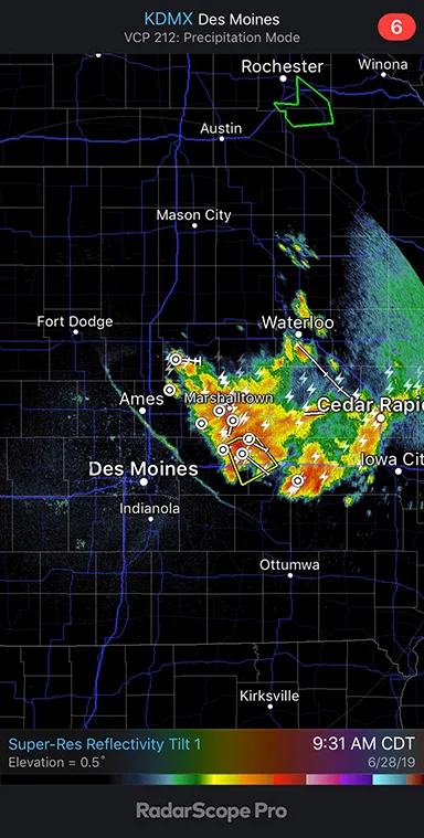
The gust front is the leading edge of the onslaught. Gust fronts are sometimes visible on National Weather Service Doppler radars, as it is in this example. The radar picks up boundaries between warm and cool air. It also is able to detect insects. These radars operate in different modes which allow meteorologists to make the radar more or less sensitive, matching the radar to atmospheric conditions to help them observe what is happening.

The radar image above is from 9:31 am CDT on June 28, 2019. It shows a gust front from northwest to southeast through Ames . The line marks the leading edge of cooler air flowing southwestward out of thunderstorms to the northeast.

Wind speeds along a gust front may be quite strong, sometimes more than 50 mph. In extreme cases speeds winds may exceed 100 mph. Cooler air is heavier than warm air so it flows down and out of a thunderstorm. Depending on the storm and its environment, the outflow spreads in different directions. Most often it moves in advance of a thunderstorm but in this case the outflow was also spreading west and southwest away storms that were moving to the southeast. The radar clearly shows the leading edge of the advance.

Below I have added a very short video from Sunday, June 30, 2019 at 7:02 pm CDT showing cooler air moving toward the southwest. The boundary became visible on radar as it approached the radar location near Johnston, Iowa. Low level winds, like gust fronts, are more likely to be detected when they are close to the radar. Why: The radar beam is higher off the ground at greater distances from the radar making the beam too high to see the leading edge of the cool air. Once the outflow gets close enough to the radar, and conditions are right, it becomes visible on radar. The video was taken with an iPhone XR using the RadarScope Pro App.

Arcus - Nature’s Wind Bag

Arcus is a low dense horizontal cloud that forms along the leading edge of some thunderstorms. Arcus come in two distinct forms; a shelf cloud or a horizontal roll cloud. When an entire arcus is observed it is often curved or a partial ring shape is visible - like an arc or segment of a circle. They form where the leading edge of cool air descending from the thunderstorm interacts with warm moist air streaming into the storm.

Arcus usually look very menacing. They are associated with strong straight-line winds rushing out of an approaching thunderstorm. Wind speeds can be too weak to cause damage in some situations or sometimes more than 100 mph in extreme cases. Winds of 45 to 70 mph are most common.

Arcus do not produce tornadoes but turbulence can create very chaotic conditions as winds rapidly change direction and speed. Circular motion is usually visible from under the cloud, as you can see in the video above. However the rotation is not caused by a tornado. Tornadoes are attached to the parent thunderstorm not an arcus cloud. However, it is possible for vertical rotation to occur along an arcus, and it could cause damage, but it is not a tornado. It is a good idea to be in shelter as the storm approaches.

The video above was recorded from underneath an arcus. It shows the turbulent flow. This cloud passed over with strong winds that littered the ground with small twigs and branches. It did not produce structural damage. This is typical of arcus. However, strong storms may produce downdrafts that do cause damage and for that reason it is a good idea to seek shelter when arcus approaches. The turbulence is very evident in this video.

In this video you will hear the wind blowing through the trees and into the microphone and you will also hear the call of a cardinal in the background.