Variety's the very spice of life, that gives it all its flavor. - William Cowper
/Variety in the sky raises many questions. Why are there multiple cloud types in the sky at the same time? What processes are causing these cloud types? Why do some of the clouds look like tufts of wool (floccus) while others are a hybrid of stratus and cumulus types. Why do some look like waves? (Hint: They are waves.) When looking at clouds - look closely. The shapes reveal the processes and air motions overhead.
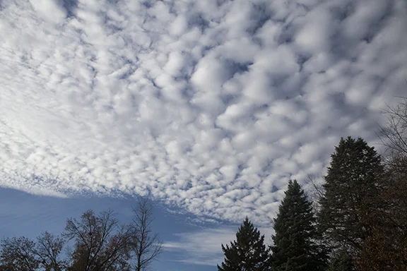
This morning we had three distinct different types of altocumulus in the sky. The first photo was taken looking to the southeast, the second was to the north, and the third was looking to the south. The photos were all taken within a few minutes of each other. Prairie skies are very interesting indeed!
Photo Copyright by Craig Johnson, 12-2-2017
The photo above is a good example of altocumulus floccus. The floccus form is concentrated in the right half of the photo.
Photo Copyright by Craig Johnson, 12-2-2017
The second photo is altocumulus stratiformis and altocumulus floccus. The floccus are identified by their puffy 'tufts of wool' look while the stratiformis are a flatter version of altocumulus. These types are mixed together in the photo above. It is easy to see that identifying cloud types is not always a clear-cut decision. Cloud processes and air motion are often part of a continuum rather than discreet structures. We often need to identify what are the dominate cloud types because cloud structures do not always fit into nice neat packages.
This tells us something about the complexity of our atmosphere. It is fluid with its motions transitioning in an infinite variety of ways. Many times we can look at clouds and see basic identifiable structures. However - don't stop there! Look closer and notice what is in the fine details. Try to imagine the type of flow that is creating the shapes you see. Sometimes the flow is what it seems to be. Other times the shapes are the result of secondary flow which requires more study. I will try to point out some of these differences in future posts.
Photo Copyright by Craig Johnson, 12-2-2017
The third photo is altocumulus undulatus. There are several formations working together. The first are the clumps of cumulus that make up the overall structure. These clumps are arranged in bands caused by
Photo by Craig Johnson, 12-01-2017
The last photo is looking south. Note the unusual very thin altocumulus undulatus extending from the center to the right. These wavy clouds are subtle waves moving from right to left (west to east). These clouds were at a lower level than the more predominate clouds elsewhere in the photo. Wave type clouds are typically caused by gravity waves.


