When is Science Really Science?

When scientists review the work of other scientists, part of the process involves evaluating the methods used to gather the data and draw conclusions. When it is done as part of a formal review process it's called peer-review. This video describes a process to gather data and draw conclusions about global temperature change. How data is manipulated directly affects the outcome of the research. This presentation is a must see for students of science. Is the data being gathered and used in a scientific manner? Why or why not? 

Anti-solar Rays

pHOTO BY cRAIG jOHNSON

pHOTO BY cRAIG jOHNSON

These are anti-solar rays. They are occasionally/rarely visible in the sky opposite the Sun. The Sun must be low in the sky - less than 20 degrees above the horizon. The alternating dark and light bands are caused by shadows from clouds. Dark bands are shadows, the light bands are sunlight scattered by dust and water vapor in the atmosphere. Without the shadows there would be no banding, just the typical uniform scattering of light normally visible in the sky.

The photo above was taken near sunset and is looking east near Cedar Falls, Iowa. The setting Sun is behind the photographer. Notice how the bands appear to converge to a single point. This is an illusion. The rays are actually parallel. The same illusion is seen when looking into the distance along a railroad track or highway. The rails or roadway appear to converge to a point. The next time you watch a sunset - turn around. You might see anti-solar rays behind you. 

Incubating Thunderstorm

This video is looking up into thunderstorms forming over Black Hawk County, Iowa on Saturday afternoon, July 23, 2016. Numerous small cells were congealing into a thunderstorm complex on a very warm and humid afternoon. This is the beginning of what turned into a severe thunderstorm complex that moved eastward to the Dubuque, Iowa area into northern Illinois. Cumulus clouds grew into cumulus congestus and cumulonimbus during a 45 minute period. Only a few brief downpours occurred here but nearly continuous thunder was heard to the east and southeast. The National Weather Service issued numerous severe weather warnings from Waterloo east along and near Highway 20 through the Dubuque area.

Thunder on the Plains

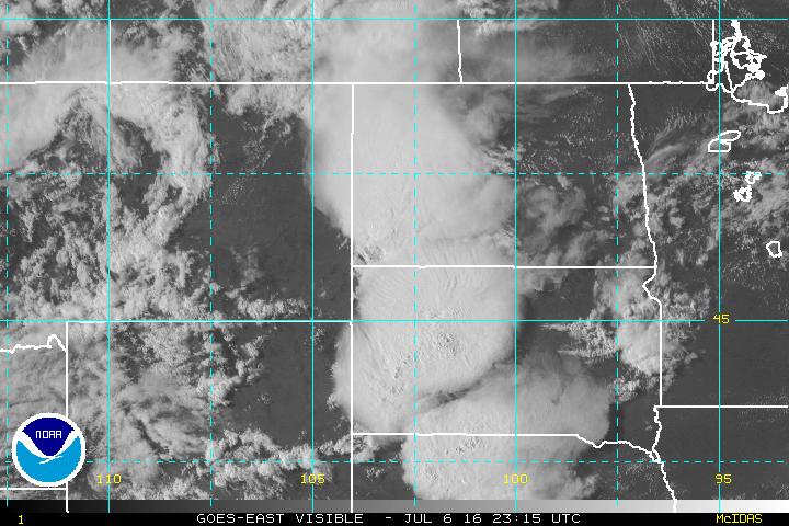
Three areas of thunderstorms developed this afternoon over eastern Montana, eastern Wyoming, and eastern Colorado. As of 6:45 p.m. CDT the storms extended from western North Dakota to western Nebraska and are moving eastward. Tornado and Severe Thunderstorm Watches are strung out along the entire length of the thunderstorm clusters along with numerous Severe Thunderstorm and Tornado Warnings.

The storm clusters are visible on this GOES visible satellite imagery at 6:15 p.m., July 6, 2016. The storm tops are visible as dense circular cloud masses. The storms will continue moving eastward and will likely merge into a large thunderstorm complex with its core over South Dakota and northern Nebraska. The storms should move east before turning slightly southeast over northern into central Iowa overnight. Other storms should continue across much of Minnesota. Damaging winds, hail, and heavy rain will be likely with the main storm complex and tornadoes are also possible as the cells organize before the system evolves into a more outflow dominated system as it crosses central and eastern portions of Iowa. Small leading edge tornadoes could occur as the system moves east-southeast. For the lasted forecast check the National Weather Service at www.weather.gov and the Storm Prediction Center and your local news media. This site isproviding a general discussion about the storms but not regular updates.

Midwest Thunderstorms

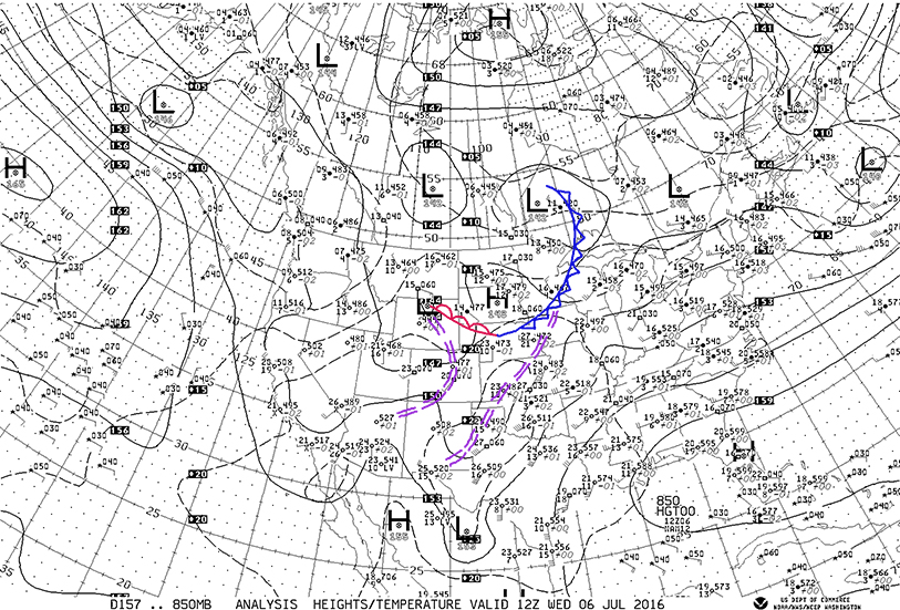
After a night of thunderstorms in parts of the Midwest more storms are expected today and tonight. The map below shows the upper air flow this morning at 7:00 CDT, Wednesday, July 6, 2016 at 850 millibars (850 mb) which is at about 5000 feet. The map is analyzed for fronts and troughs in the Midwest. An upper cold front (blue) was located from western Ontario through northwestern Wisconsin, southeast Minnesota, northwest Iowa to an upper warm front (red) from western Nebraska into northeastern Wyoming. Upper troughs are located from northcentral Iowa to southeast New Mexico and from Wyoming to Colorado, to northwest Arizona.

There is a general southwest flow of air from western Texas to the Great Lakes and Ohio Valley. A northwest flow is located behind the upper cold front. A southerly flow is getting re-established from western Kansas/Nebraska to the boundary across northern Nebraska, to southeastern Montana. This southerly flow is relatively dry over Nebraska, Colorado, and most of Kansas which will inhibit but not eliminate thunderstorm development this afternoon over the Central Plains. Look for scattered storms to form in the western High Plains as moisture gradually increase.


An interesting feature of the air mass over the Central Midwest is the lack of wide spread deep moisture over the Plains. The upper air sounding from Omaha this morning illustrates the issue. The dashed green line is the dew point while the red line is temperature. On the chart temperature increases to the right and altitude increases upward. Notice how the green line jumps to the left near the bottom - that indicates dry air just off the surface through 10,000 feet.

Notice the northeast winds at the surface (see the right vertical bar) which switch to westerly at about 5000 feet and increase with height. The wide separation of the green and red lines are regions of the driest air.

As southerly flow increases from Kansas to South Dakota pockets of moist air will likely help develop thunderstorms over South Dakota and Wyoming later today and tonight. Thunderstorms should develop north of the boundary that now extends from Wyoming (warm front aloft) to Nebraska (cold front) and move east or southeastward. Increasing moisture over Iowa should allow the storms to grow as they move east or southeastward toward Minnesota and Iowa. 

The upper air flow at about 18,000 feet (500 millibars) is shown below. Notice the increasing winds generally from west to east over the northern U.S. and the vigorous low pressure moving through the Pacific Northwest. This is an area of colder air aloft that will spread eastward and destabilize the air over the Upper Midwest Thursday. Look for a major outbreak of severe weather over Iowa as this system moves eastward. For more information on your forecast go to www.weather.gov and also the Storm Prediction Center websites.

Notice the temperatures at 18,000 feet. Davenport, Iowa is -8 degrees centigrade while Great Falls, Montana is -16 centigrade. The strongerflow that will develop at all levels tonight and Thursday will help generate severe thunderstorms across the Upper Midwest starting late this afternoon in southeast Montana, northeast Wyoming, and western South Dakota. The storms should move to the east and southeast with damaging winds and hail and possibly locally heavy rains although the forward motion should somewhat limit flooding except in places where the ground is already soaked. More on this later.

The lightning flash captured here happened during a May 20 storm not far from the Florida Tech campus in Melbourne. It was recorded at 7,000 frames per second using a high-speed camera.

Video courtesy of the Geospace Physics Laboratory, Department of Physics and Space Sciences, Florida Institute of Technology.

The Principal Investigator is Ningyu Liu from the Geospace Physics Laboratory in Florida Tech’s Department of Physics and Space Sciences

CONTRAILS (Condensation Trails)

Photo Courtesy of the NASA Langley Research Center

Photo Courtesy of the NASA Langley Research Center

This is an interesting photo from NASA Langley Research Center. It shows condensation trails (contrails for short) over the southeastern United States. These line shaped clouds form from the condensation of water vapor in the exhaust of high flying jet aircraft. Temperatures are extremely cold at the cruising altitudes of commercial aircraft so the contrails are made primarily of ice crystals.

Upper Air Sounding (Radiosonde) from Omaha, Nebraska

Plot of a Radiosonde launched at Omaha, Nebraska this evening (7:00 p.m. CDT on June 20th). The program used to plot the data is Raob.

Plot of a Radiosonde launched at Omaha, Nebraska this evening (7:00 p.m. CDT on June 20th). The program used to plot the data is Raob.

Above is the upper air sounding from Omaha, Nebraska this evening (7:00 p.m. CDT, June 20th). While a great deal of information can be obtained from an upper air sounding we will focus on three things this evening. Over time I will point out other features. Down the right hand side is the altitude scale with thousands of feet on the right side of the scale. The wind barbs are also plotted vertically to the right. Winds are from the north and northeast up to about 5,000 feet. Above the winds are from the west and northwest. The red line is the temperature and the dashed green line is the dew point, both plotted vertically. At the time of the sounding Omaha reported temperatures in the upper 60s at the surface due to rain cooled air covering the area. Outside of the rain area temperatures were in the 90s (not shown here).

Notice how the red line is shifted left (cooler) near the bottom of the chart but quickly warms above the surface. This marks a low level inversion (region of cooler temperatures below warmer air aloft. The normal pattern of air being cooler with height is "inverted" due to cooling caused by evaporation of falling rain at the surface. The wind at the surface is from the north and northeast out of thunderstorms that were moving just to the north and northeast of Omaha. The outflow from these storms was moving to the west and south covering Omaha with a layer of cooler air. Above the cooler air the wind is from the west and is increasing speed with height.

To learn more about reading the feathers and arrows used to plot the winds refer to the home page of this website. Examples and an explanation are available at no cost.

Thunderstorm Threat Growing

The threat of thunderstorms with heavy rain and severe weather is growing for the middle of the U.S. As mentioned here on Saturday (June 18th) a large dome of warm air aloft and the main upper level flow steering around it is expected to flatten early this week and allow thunderstorms to return to the Upper Midwest. This afternoon temperatures have been in the 90s over most of Kansas with readings reaching at least 100 at Salina and Manhattan. These storms are occurring near a boundary between the hot air occupying the Desert Southwest and Southern Plains with cooler air to the northeast. As the flow aloft is pushed to the northeast once again more storms are expected along the nose of the hot air from the Dakotas, Nebraska, Minnesota, Iowa, and Missouri along with parts of Wisconsin and Illinois. As the pattern shifts northeast Tuesday and Wednesday the storm cells will likely move from northwest to southeast being fed by a southerly flow at the surface bringing moisture north underneath a west to northwest flow aloft. Storms in this scenario favor the afternoon through nighttime hours before ending after daylight.

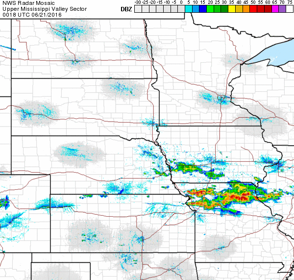
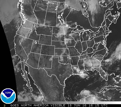
Below are satellite and radar images from late this afternoon showing storm clusters in Iowa and Missouri.

Radar Image from the National Weather Service at 7:18 p.m. CDT, 20 June 2016

Radar Image from the National Weather Service at 7:18 p.m. CDT, 20 June 2016

Strong thunderstorms are shown on this satellite image in northern Missouri and also over Indiana. Smaller cells are in southern Nebraska.  Thunderstorms are also indicated over southwest Iowa. More of the same is expected the next few days as the pattern shifts to the northeast. Check your local forecast for details.

GOES Visible Satellite Image at 6:45 CDT

GOES Visible Satellite Image at 6:45 CDT

A Tussle Aloft

500 Millibar heights in decimeters. Forecast for 7:00 a.m., Wednesday, June 22, 2016. High pressure ridge is pronounced from Eastern Colorado north over the Dakotas into Canada. The strongest flow of the Westerlies ranging from 40 to about 60 mph ex…

500 Millibar heights in decimeters. Forecast for 7:00 a.m., Wednesday, June 22, 2016. High pressure ridge is pronounced from Eastern Colorado north over the Dakotas into Canada. The strongest flow of the Westerlies ranging from 40 to about 60 mph extends from Northern California to Montana, the ND-SD border to Northern Illinois and Virginia then off the New England coast.

There is a tussle underway between a large high pressure ridge dominating the area from the Desert Southwest to the Midwest and core of the Westerlies aloft from the Pacific Northwest to the Northern Midwest. The ridge is a mound of warm air at the surface and aloft which is in the area south of the 588 line on the forecast 500 millibar map for Wednesday, June 22nd at 7:00 a.m. CDT. Temperatures in the 80s and 90s are common under the ridge with readings topping 100 in the Desert Southwest. The main flow aloft at about 18,000 feet (500 millibars) is being steered around the northern edge of the ridge.

During the next few days we should see a northwest flow of air aloft increase over the Upper Midwest. This pattern is favorable for showers and thunderstorms, especially from late afternoon overnight into the morning. The nighttime component of these storms is a major rain producer for the Midwest. Watch for this pattern to develop and for thunderstorms to become more numerous from the Dakotas southeastward through parts of Minnesota, Nebraska, Iowa, Illinois, Missouri, northeastern Kansas, to the east from Monday into Thursday. Locally heavy rain, large hail, strong winds and tornadoes are possible in this situation. Other isolated thunderstorms may form at random under the warm high pressure area.


Summer Heat

500 MB Chart, 7:00 a.m. CDT, 18 June 2016, from NOAA

500 MB Chart, 7:00 a.m. CDT, 18 June 2016, from NOAA

A large area of high pressure aloft extends from the Desert Southwest into the middle of the United States this morning. This high pressure aloft (at the 500 millibar level, approximately 18,000 feet) has been responsible for the hot dry weather in the Southwest with readings in the 90s and 80s over the Plains and much of the central and eastern U.S. The hottest weather is occurring under the high pressure center over Arizona, New Mexico northeast to the Central and Southern High Plains. A few thunderstorm clusters, typical of this type of summer pattern, formed in Minnesota, South Dakota, Nebraska, and Kansas. The strongest flow aloft has been forced around the warm air aloft from Northern California into southern and eastern Canada. Scattered thunderstorms are possible today around the northwest and northern edge of the high pressure and also over the Plains. Check your local forecast for details. Cooler temperatures are in the Pacific Northwest and the Great Lakes to New England.

The visible satellite image below from the National Weather Service at 11:15 a.m. CDT shows the remnants of thunderstorms that occurred over the Plains last night and early today. The clouds are mainly middle and high level clouds leftover from rained out thunderstorms. The clouds are located this morning over  Iowa, Kansas, and Oklahoma. The cloud band from the Dakotas to western Minnesota is part of a system moving with the stronger SW to NE flow aloft crossing the Dakotas. It contains weakening showers that should dissipate before regenerating this afternoon and evening as it moves over Northern Minnesota, Lake Superior, and into Canada. Thunderstorms are also occurring over Louisiana and northeastern Florida.

Low pressure aloft along the Washington-Oregon coast is creating showers in parts of Washington and Oregon with very spotty activity in the Idaho panhandle and northwestern Montana. As the system moves northeast thunderstorms are likely this afternoon over parts of northern Montana as cooler air aloft rides over warmer and relatively moist low level air.

Springtime Weather Extremes

With spring comes weather extremes. The are several reasons why but one of the most important is advancing warmer air moving north in response to the Sun moving higher in the Northern Hemisphere sky. Storms tend to travel parallel to the boundary dividing cold from warm air.

The map above shows the boundary with a storm centered over southeastern Minnesota. The red and blue dashed lines extending from Canada to the Dakotas, Minnesota, to Wisconsin and Michigan show the greatest temperature change. Generally the change from red to blue lines is the dividing line between rain and snow. Iowa will experience a milder day today as west and southwest winds sweep across the state bringing warmer air from the Plains across the state. Readings will be in the 60s and 70s - a far cry from the colder weather of the past couple of days.

The map is the forecast for 1:00 p.m. CDT this afternoon (Sunday, April 3rd). The bulls-eye over southeast Minnesota is the predicted center of low pressure at 1:00 p.m. In the meantime much colder air and snow occupies the area from northern Minnesota across the Great Lakes to New England.  Springtime does bring extremes across both distance and time.

Altocumulus lenticularis

This photo shows a layer of altostratus on top with wavy altocumulus lenticularis below. Altostratus means "high stratus' and altocumulus is "high cumulus." Lenticularis indicates the clouds are lens shaped. The lenticularis pattern is created atmospheric waves create undulations in the flow. If the wavy motion is in a moist layer condensation occurs in rising air near the wave crests while evaporation occurs where the air is sinking.  Aircraft flying atmospheric waves will often get a rough ride.

Unusual Altocumulus

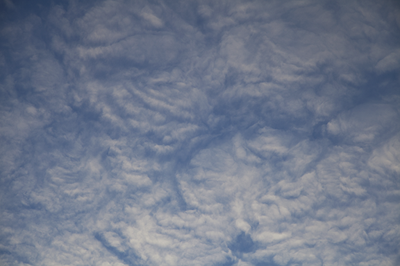
This unusual layer of altocumulus clouds was visible from Cedar Falls this morning shortly after 7:30 CST. The top photo shows a wide view (17 mm) while the bottom photo was shot at 104 mm. I have watch the sky for over 60 years and have never seen a formation quite like this. There appears to be a combination of gravity waves acting with weak convective instability in an area of warm advection aloft to create the pattern. The cloud area was moving toward the south (L to R). The surface air temperature was 6 degrees F.

500 Millibar Level (approximately 18,000 feet)

500 Millibar Level (approximately 18,000 feet)

To most people this chart looks something like a bowl of spaghetti. At first glance the squiggly lines seem to wander all over the place, making little sense. Meteorologists call this the 500 millibar chart. Instead of plotting weather data such as temperature, wind, and moisture at a specified altitude it is plotted at a specified pressure - 500 millibars. The 500 millibar pressure reading is higher in some locations and lower in other. It just so happens that at 500 millibars half of the mass of the atmosphere is above 500 millibars and half is below it. Its altitude is roughly at 18,000 feet.

Pressure maps are similar to a topographical map that we use to show variations in the altitude of land. The highest points on the map above (marked by an "H") are like mountains - the 500 millibar pressure is found at a higher altitude than at the low points which are marked by an "L". The solid lines in between the Hs and Ls are the same as lines on a topographical map. Just like on a topographical map, the closer the lines are together the steeper the slope. The farther they are apart the flatter the terrain. In our case the winds are stronger where the lines are close together.

On this chart you are looking down over the North Pole. The flow at 500 millibars is meandering from west to east around the pole. This west to east flow is found generally north of 25 to 30 N latitude. As the flow dips southward cold air is flowing away from the polar areas. Where it turns back to the north warm air is moving away from the topics. This process is part of the Earth's natural temperature regulation.

Notice the dip southeastward in the flow from western Canada to the Upper Midwest. This is a new push of colder air headed toward the Upper Midwest. Areas of snow and blowing snow expected to cause blizzard or near blizzard conditions and drop temperatures considerably.  See www.weather.gov for more information on the latest forecast.

The winds aloft are strongest where the lines are closest together. When the lines are close together it is call a tight gradient. Where the lines are far  apart it is a weak gradient and winds are weak. It is the general west to east flow that brings periods of stormy and calm weather. It is the ever-changing flow that determines what the next few days will be like. More about that in another post.


Snow Bands

Moderate to heavy snow has been falling in Cedar Falls this morning. It was been literally pouring snow due to the convection embedded in the precipitation. So far I have heard one crack of thunder (see post below). The radar image above is showing the precipitation intensity. The green areas are the heaviest bands of snow and are quite likely associated with the convection. The heavier snow bands are producing snowfall rates of up to 3 inches per hour. 

Heavy Snow and Thunder

There was thunder this morning. Yes it can thunder in winter. While thunder is more common the warm months it does occasionally happen during the winter. It isn't the temperature that matters, it is the difference in temperature. If the atmosphere is unstable due to warmer moist air rising through a cooler air column it doesn't matter whether the warm air is 32 degrees or 82 degrees. As long as the difference between the warmer and cooler air is sufficient to create a vigorous column of rising air and there is enough ice and water in the storm - lightning is possible. Where there is lightning there is thunder. Instead of pouring rain it was pouring snow!


Fog before the Storm

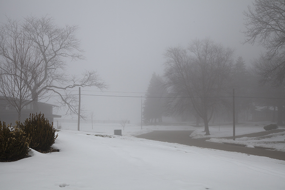
Yesterday (Monday) morning began with fog. Daytime temperatures have been in the upper 30s and 40s during the past couple of days which melted a considerable amount of snow. The weak upper level system that brought clouds and some light precipitation to Iowa Saturday night and Sunday moved east late Sunday clearing the skies. Clear skies, nearly calm winds, and low level moisture from the melting snow was a perfect set up for fog. The fog hung on until winds began to pick up ahead of the large winter storm that has now reached Iowa.  

The first photo shows the effect of diminishing visibility as we look north. Note the clearly visible bushes in the foreground and how objects in the distance grow dimmer as light reflected off the trees, homes, and a fence on the hilltop is filtered by the small droplets in the fog.

The photo below enhances the effect. The flag pole in the foreground is distinctly visible but the successive objects fade into the distance as the fog cuts down on the light reaching the camera from the decorative fencing and trees in the distance. The visibility was down to 1/4 of a mile in some locations. 

Still Waiting

A large winter storm crossing the West Coast is expected to move eastward through the Rockies into the central U.S. during the next 24 to 48 hours. When the earliest European settlers arrived in Iowa in the 1830s they did not have the luxury of knowing if the weather was going to change. Like the natives they learned to watch the sky, notice the wind, and use weather lore for hints of change. Sometimes the severity of the changes would elude them until it was too late. Today is a great example. Today the weather is very innocent. Clouds have covered the sky much of the day but there is certainly no hint of a big snowstorm on the horizon that would bring great hardship and perhaps death to the unknowing traveler. Temperatures are in the upper 30s and 40s. 

The National Weather Service surface weather map shows the associated weather with the western storm. It also shows a generally dry pattern over the central U.S: "The calm before the storm."

Widespread snow is expected through out the west particularly over the mountains and plateau. You can learn the details of local forecasts at www.weather.gov.

Upper level winds at 500 millibars (approximately 18,000 feet) show the upper trough crossing the west coast at 6 a.m. this morning. The trough is the core of cold air aloft. This storm is the real deal as we shall see once it reaches the Plains and feasts on moisture from the Gulf of Mexico.

500 millibar chart courtesy of the National Center for Environmental Prediction. Deep trough is digging southeastward along the west coast.

500 millibar chart courtesy of the National Center for Environmental Prediction. Deep trough is digging southeastward along the west coast.

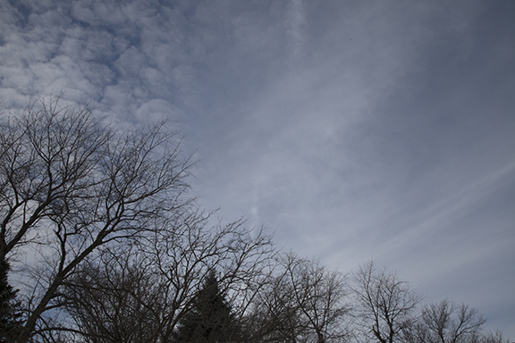
The map also shows a weak upper level system crossing the Upper Midwest. This system spread light precipitation in the form of rain and snow from Colorado to the Upper Midwest from Saturday into Sunday. The photo below looking north from Cedar Falls, Iowa this afternoon shows the back edge of an altocumulus cloud layer associated with this weak system.

Looking north in Cedar Falls, Iowa at 4:00 p.m. CST. Clearing skies behind weak trough crossing Iowa.

Looking north in Cedar Falls, Iowa at 4:00 p.m. CST. Clearing skies behind weak trough crossing Iowa.

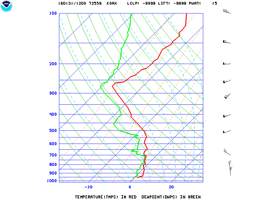
It is interesting to compare the upper air soundings (radiosonde or RAOBs) from Omaha and North Platte, NE this morning. Clouds and precipitation aloft formed ahead of the weak system moving into the Midwest where the air is rising. The RAOB from Omaha shows the moisture in the mid-levels between 800 and 700 millibars, which is a layer between 4,000 to 10,000 feet. Notice how the green dew point line moves closer to the red temperature plot on the chart below. Where the dew point and temperature are close together the relative humidity is high. This marks the area of cloudiness above and east of Omaha this morning.

Radiosonde sounding from NWS at Omaha Valley, NE. Relative Humidity is high where red (temperature) and Green (Dew Point) lines meet.

Radiosonde sounding from NWS at Omaha Valley, NE. Relative Humidity is high where red (temperature) and Green (Dew Point) lines meet.

The next sounding is from North Platte. Notice the atmosphere is drier at same level we looked at over Omaha. The spread between the dew point (green) and temperature (red) is much larger. This is a layer of dry air moving east over Nebraska in an area of downward motion behind the week trough over Iowa and eastern Nebraska. As this dry air moved east today it brought decreasing cloudiness to Iowa allowing the Sun to shine in some places behind the trough.

North Platte sounding shows dry air from just above the surface to about 600 millibars (approximately 13,000 feet).

North Platte sounding shows dry air from just above the surface to about 600 millibars (approximately 13,000 feet).

So what's next? We will watch the western storm move eastward. We expect a surface low to develop east of the Rockies over the Southern Plains before it turns northeastward. A Blizzard Watch covers much of western and northern Iowa into Eastern Nebraska. Around it are Winter Storm Warnings and to the southwest are Blizzard Warnings and Winter Storm Warnings. See the latest at www.weather.gov.

Here is a rather innocent picture looking southeast from Cedar Falls this afternoon. Altocumulus clouds dominate the sky as a weak upper trough moves eastward overhead. We are in the "calm before the storm." I will use this and the previous images as a comparison, before and after the storm. If all goes as planned these scenes will look much different in a couple of days. The difference between now and the mid-1800s is that we know about these storms well in advance. Early settlers and natives did not have that luxury and people paid the ultimate price.

Looking southeast at about 4:00 p.m. CST. Altocumulus cloud deck is moving to the southeast. 

Educational hint: Go back to our homepage and scroll down the page until you find the weather code downloads. In the materials available you will find a chart showing all of the weather plotting codes. The wind plots show how to read the wind direction and speed from station model plots. Use the explanation on the chart to read the wind barbs on the upper air map above.

Calm Before the Storm

"The calm before the storm." It's a period of quiet weather that sometimes precedes major storms. The air is nearly calm, the sky has an innocent look, betraying what is about to happen. But there is a reason for it. Quite often large scale vertical air motions are downward ahead of major storm systems. What goes up must come down. Large storm systems feature vast regions of rising motion. Rising motion, with sufficient moisture, causes the air to cool to its condensation temperature and develops clouds and eventually precipitation. Around the storm there must be compensating areas of downward motion - areas where clouds dissipate or do not appear threatening. It is the calm before the storm.

Here are three photos taken early this afternoon in Cedar Falls, Iowa. The first looks south, the second southwest, and the third west. The south and southwestern views feature altocumulus and cirrus clouds. Altocumulus are middle level clouds and the cirrus are higher. No precipitation falls from altocumulus. Cirrus often has fall streaks, downward streamers of ice crystals that do not reach the ground. It is why cirrus often look wispy. The west view shows cirrus obscured by falling ice crystals. The photo is looking almost straight up into the cloud layer.  The fall streaks are falling directly toward the camera causing an indistinct cloud base. 

A plume of moisture in a relatively milder west to east flow aloft is responsible. Areas of weak upward motion creates the altocumulus and cirrus. This is the leading edge of a band of weak upward motion well in advance of a major storm centered off the West Coast. That storm should reach Iowa by late Monday with a big dose of winter weather due to continue into Wednesday. So today is the, "calm before the storm." Sunday and Monday our weather gradually gets more complicated.

Altocumulus (top right), altostratus (bottom), and cirrus (middle) south 30Jan2016, 12:30 p.m. cst

Altocumulus (top right), altostratus (bottom), and cirrus (middle) south 30Jan2016, 12:30 p.m. cst

altocumulus SW 30Jan2016 12:30 pm cst

altocumulus SW 30Jan2016 12:30 pm cst

altocumulus (left) and Cirrus fall streaks, west, 12:30 p.m. cst

altocumulus (left) and Cirrus fall streaks, west, 12:30 p.m. cst