Passing Cold Front

Another cold front passed by yesterday giving us a brief encounter with mild temperatures. It lasted about 2 hours when our high temperature touched 62 degrees. As the front approached scattered clouds formed. The photo below shows strips of altostratus with a few rag tag fractured cloud tags. At this point winds were breezy from the west and southwest.

Altostratus and fractus clouds. Cedar Falls, Iowa. Photo by Craig Johnson. Copyright 2018

Altostratus and fractus clouds. Cedar Falls, Iowa. Photo by Craig Johnson. Copyright 2018

This close-up in the photo below of an expanding area of altostratus was taken near the leading edge of the cold front.

Close-up of altostratus and fractured clouds. Cedar Falls, Iowa. Photo by Craig Johnson. Copyright 2018

Close-up of altostratus and fractured clouds. Cedar Falls, Iowa. Photo by Craig Johnson. Copyright 2018

As the front passed this patch of altocumulus shown below moved over head.

Altocumulus. Cedar Falls, Iowa. Photo by Craig Johnson. Copyright 2018

Altocumulus. Cedar Falls, Iowa. Photo by Craig Johnson. Copyright 2018

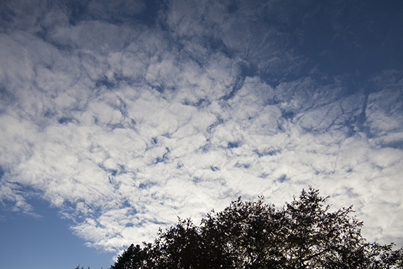
The next photo shows a close-up of the altocumulus. Notice the cell structure of this cloud time. The cloud layer is divided into cloud cells with lines of nearly clear sky around each cell. It should be pointed out that the areas of clear or nearly clear skies in the altocumulus are caused by sinking air. The clouds are found where condensation occurs in areas of rising motion. By contrast, the altostratus clouds are in a mostly continuous layer or sheet. Altostratus also occur in rising motion but rising motion with stratus type clouds is slower than in cumulus type clouds.

Close-up of altocumulus. Cedar Falls, Iowa. Photo by Craig Johnson. Copyright 2018

Close-up of altocumulus. Cedar Falls, Iowa. Photo by Craig Johnson. Copyright 2018

The First Measurable Snow of the Season

First snow of the season for Cedar Falls, Iowa, Photo by Craig Johnson, CopyRIGHT 2018

First snow of the season for Cedar Falls, Iowa, Photo by Craig Johnson, CopyRIGHT 2018

The first snow arrived early this year. October 14th is early. While a few flakes sometimes fly in October it is not common to have measurable snow this early. The day started with rain but by afternoon, as colder air moved in, it changed to what you see in this photo - large flakes collecting on grassy surfaces.

Temperatures were relatively warm - in the 30s. When temperatures are just above freezing the flakes are usually large due to moisture that condenses on the falling flakes making them “sticky.” Flakes stick together and condensation continues to grow the existing ice crystals creating the large flakes. The large flakes are easily visible in the photo. In the end we measured .3 (three-tenths) inches of snow, which melted almost immediately. We did manage to have scattered snow still on the ground the next morning but it melted quickly. It is all a reminder that winter cannot be far behind, although it is still anyone’s guess how soon a “serious” snowfall will occur.

Photo by Craig Johnson, Copyright 2018

Photo by Craig Johnson, Copyright 2018

Compare this photo to the previous post. The photos were taken about 30 minutes apart. Evaporation is taking place leaving clear patches in between the thicker cumulus clouds. So instead of a nearly continuous cloud layer we now have holes developing as drier air above the cloud area sinks through thinner portions of the cloud. Instead of stratocumulus the cloud type is now mainly cumulus. The next stage was the weakening of the upward motion that was making the cumulus clouds. After sunset the cumulus flattened into thin patches of stratocumulus.

Stratus or Cumulus?

Photo by Craig Johnson, Copyright 2018

Photo by Craig Johnson, Copyright 2018

What kind of cloud is this? It looks heaped which suggests it is a type of cumulus. On the other hand it also has some stratus characteristics - layered and areas that are flat. Meteorologists combine the two types into one - stratocumulus. This type has both cumulus and stratus elements. In this case the stratocumulus formed in seasonably cold air flowing into a departing low pressure area. The air above this cloud is sinking. Sinking dry air warms at 5.5 degrees F for each 1,000 feet it descends due to the higher air pressure at lower levels. The warming creates a layer of relatively warm air (but not necessarily warm) above the cool air below. The layer is stable - the lower air cannot rise through the upper layer. The result is a nearly continuous cloud with a flat layer expanse.

At the same time the cumulus shape forms when moist air near the surface rises during the heat of the day. The rising air cools and water vapor condenses into puffy cumulus cloud elements. In the end the combination of rising and sinking motion create a cloud that looks both cumulus and stratus at the same time - stratocumulus. By late afternoon the surface heating weakens as the Sun sinks lower in the sky. The cumulus elements disappear leaving a dissipating flat cloud that evaporates leaving a clear chilly night.

Increasing Clouds

Autumn storms provide longer advance warning of their arrival than summer storms. The reason is the change in what causes storms during each season. Summer storms are smaller in horizontal extent than winter storms. They are also have much shorter life-spans. Winter storms are not as tall as summer storms. Summer storms develop quickly, winter storms take many hours or days to develop after they are identified.

NOTE: There is rarely a situation where storms are completely a “summer” or a “winter” storm. I am using that comparison to help readers understand that there are usually major differences in what causes storms to form and develop and how long they live during summer and winter.

Summer storms form and live off large amounts of warm air and moisture and flow patterns. Winter storms form and live off changes in temperature wind velocity with height.

The heat and moisture available in summer are the main driver of summer thunderstorms. Flow patterns determine the type of thunderstorm and severity. Winter storms depend on air flow vertically through the atmosphere. Differences in temperature, moisture, and flow patterns shape the intensity and type of storms. Those differences cause summer storms to be relatively small in size when compared to winter storms but summer storms are usually taller than winter storms. Winter storms sprawl over several states at once, sometimes influencing weather in one-third to one-half of the nation. Commercial airliners go around thunderstorms but can usually fly over winter storms.

Today was a good example of how the sky looks in winter compared to summer. On the prairie we can see storms coming for many miles so it is easy to change in cloud types when looking from horizon to horizon. The flat clouds of winter were on display. Below are several pictures of the sky this afternoon. From the top picture to the bottom the evolution of clouds indicated more of a winter than summer type storm was approaching. It is too bad the Sun went down because there would have been more to see.

Cirrus own the high altitudes. A commercial airliner flies between bands of cirrus in this photo looking south from Cedar Falls, Iowa. cirrus often mark a change in the weather if the clouds thicken and lower in time. Most cirrus are made entirely o…

Cirrus own the high altitudes. A commercial airliner flies between bands of cirrus in this photo looking south from Cedar Falls, Iowa. cirrus often mark a change in the weather if the clouds thicken and lower in time. Most cirrus are made entirely out of tiny ice crystals. Photo by Craig Johnson. Copyright 2018

Beautiful! These wave clouds reveal ripples in the upper level flow. These clouds were above 16,000 feet and in the Cirrus level. They are a form of Cirrocumulus and are likely made of water droplets and ice crystals.. Photo by Craig Johnson, copyri…

Beautiful! These wave clouds reveal ripples in the upper level flow. These clouds were above 16,000 feet and in the Cirrus level. They are a form of Cirrocumulus and are likely made of water droplets and ice crystals.. Photo by Craig Johnson, copyright 2018

More waves. Gravity waves create these waves and are similar to waves in a stream. These ripples cause bumpy rides on aircraft. They occur in clear air - it is clouds that make them visible. Photo by Craig Johnson, copyright 2018

More waves. Gravity waves create these waves and are similar to waves in a stream. These ripples cause bumpy rides on aircraft. They occur in clear air - it is clouds that make them visible. Photo by Craig Johnson, copyright 2018

High clouds herald an approaching storm - especially when the clouds thicken and lower. The high clouds are forming to the west and moving east well in advance of the main storm. Photo by Craig Johnson at Cedar Falls, Iowa. Copyright 2018

High clouds herald an approaching storm - especially when the clouds thicken and lower. The high clouds are forming to the west and moving east well in advance of the main storm. Photo by Craig Johnson at Cedar Falls, Iowa. Copyright 2018

Next up were MID LEVEL clouds - the puffy clouds in this photo are Altocumulus. They indicate a layer of moisture in an unstable layer at about 7.000 feet. Notice the wave pattern in the Altocumulus. These clouds show off summer (puffy) and winter (…

Next up were MID LEVEL clouds - the puffy clouds in this photo are Altocumulus. They indicate a layer of moisture in an unstable layer at about 7.000 feet. Notice the wave pattern in the Altocumulus. These clouds show off summer (puffy) and winter (waves in bands) cloud types. The bands are parallel lines much like a series of waves seen in water. Photo by Craig Johnson. COPYRIGHT 2018

This shows a growing mid-Level cloud layer. As moisture and lift increase more clouds form, thicken, and lower. The entire process shows how clouds gradually increase and change type in advance of the approaching storm. Photo by Craig Johnson, copyr…

This shows a growing mid-Level cloud layer. As moisture and lift increase more clouds form, thicken, and lower. The entire process shows how clouds gradually increase and change type in advance of the approaching storm. Photo by Craig Johnson, copyright 2018

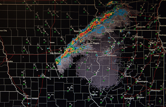
Cold Front on Radar

Radar image from the National Weather Service Office in Davenport, Iowa. It was produced by StormLab software using National Weather Service radar data available on the internet at no charge. The software is available at http://www.interwarn.com/

Radar image from the National Weather Service Office in Davenport, Iowa. It was produced by StormLab software using National Weather Service radar data available on the internet at no charge. The software is available at http://www.interwarn.com/

Last evening a cold front moved across Iowa preceded by a narrow band of thunderstorms. Nearly a quarter-inch of rain fell in about 15 minutes. That is a rainfall rate of 1 inch/hour. How about temperatures? The high temperature ahead of the front was 85 degrees. Behind the front the low this morning was 37. The warm moist air ahead of the front was lifted by the cold front along a narrow band of instability.

Autumn Rain

2018_09_29_1762-WEB-edited.jpg

National Weather Service Doppler Radar, Des Moines, Iowa, 2015Z (3:15 p.m. CDT)
Radar displayed using the Storm Lab radar display software from www.interwarm.com. This does not show the full capability of the software.

We have already broken the rainfall record for any single month with 13.90 inches as of 9-28-2018. With every new raindrop we set a new record. What makes this particularly interesting is the record is falling during September (a drier month) rather than June which is our month with heaviest rainfall. This radar image shows the beginning of a wet weekend for northeast Iowa. We will easily surpass the 14.00” mark today and with more rain possible into Tuesday we might get to 15 inches.

Altostratus at Cedar Falls, Iowa, 9-29-2018, Photo copyright Craig Johnson, Weatherbriefing.com

Altostratus at Cedar Falls, Iowa, 9-29-2018, Photo copyright Craig Johnson, Weatherbriefing.com

A solid altostratus deck covers the area today. This photo shows cloud banding that is parallel to the wind direction. It had been raining but for a moment the rain stopped and ceilings (cloud bases) lifted revealing the altostratus. Rain clouds producing steady rain are called nimbostratus. The picture below shows altostratus and nimbostratus in the same sky.

Altostratus and Nimbostratus, Photo Copyright Craig Johnson and WeatherBriefing

Altostratus and Nimbostratus, Photo Copyright Craig Johnson and WeatherBriefing

Cold Front Weather

Photo by Craig Johnson, 9-25-2018, Cedar Falls, Iowa

Photo by Craig Johnson, 9-25-2018, Cedar Falls, Iowa

This photo looking east during the late afternoon shows the backside of a cold front. Earlier in the day rain and thunderstorms crossed the state with heavy downpours and brief severe weather. Severe weather reports came from eastern Iowa where a tornado lofted 2 grain bins near Mechanicsville and winds estimated at 60 mph caused damage in the vicinity of Cedar Rapids.

The variety of clouds found in this photo show the changing air mass. The “wall” of white cloud in the distance is a line of thunderstorms that had moved out of Iowa into Wisconsin and Illinois. The cloud is the back of thunderstorms (cumulonimbus). Stratocumulus are indicated as the darker lower clouds and high in the upper right corner are either very high altocumulus or cirrocumulus. Temperatures fell from the 60s into the 50s after the passage of the front and readings will be in the 40s overnight. Autumn has arrived. Just a few days ago on September 20th we had a high temperature in Cedar Falls of 91 degrees. Welcome to weather on the prairie!

From Summer to Fall

There is a definitely a difference between “summer” clouds and “autumn” clouds. Summer clouds show more vertical development while autumn clouds begin the transition to a winter sky. Autumn brings a mix of summer and winter clouds - with more summer clouds at the beginning of autumn giving way to winter type clouds by the first day of winter. This past week the Upper Midwest turned a corner.

The following sequence of clouds occurred during an 8 day period from September 17th to September 24th. Each photo is identified by date and cloud type. The transition occurred as a cold front crossed Iowa bringing very heavy rain, river flooding, and a switch to much cooler temperatures. In the beginning, high temperatures reached 90 degrees, by the end readings topped out in the low 60s.

Cumulus Congestus. September 17, 2018 at Cedar Falls, Iowa

Cumulus Congestus. September 17, 2018 at Cedar Falls, Iowa

Cumulus congestus are one stage away from cumulonimbus (thunderstorm) clouds.

The congestus stage is part of the natural progression from the cumulus stage to the cumulonimbus stage. Sometimes the progression from smallest to the tallest clouds requires much of the day. However, on some days it can take less than an hour. The progression looks like this: cumulus, cumulus mediocris, cumulus congestus, cumulonimbus. As the clouds grow in size their tops increase in height penetrating into colder air aloft. The tops of summer thunderstorms reach heights where temperatures fall to -60 degrees F.

Precipitation may be seen falling near the end of the cumulus congestus stage, just before the cloud becomes a cumulonimbus. On the 17th thunderstorms with heavy rain developed.

Cumulus mediocris. September 19, 2018 at Cedar Falls, Iowa

Cumulus mediocris. September 19, 2018 at Cedar Falls, Iowa

As time passed the atmosphere became more stable over Iowa but not before another round of storms occurred on the 19th when the cold front crossed the state. These cumulus mediocris clouds are part of the cumulus to cumulonimbus progression. They represent the second stage in development before cumulus congestus. This cloud type does not produce precipitation. Thunderstorms with heavy rain also developed on the 19th.

Stratocumulus. September 21, 2018 at Cedar Falls, Iowa

Stratocumulus. September 21, 2018 at Cedar Falls, Iowa

Stratocumulus form in a more stable atmosphere. While the cumulus progression to thunderstorms occurs when the atmosphere is very unstable, stratocumulus occur when rising motion occurs only in the low levels. The clouds do not develop to great heights.

Stratocumulus clouds look a little like stratus (layered clouds) and a little like cumulus (unstable puffy clouds) formations. The clouds in the above photo formed behind the cold front. Stratocumulus do not produce precipitation, however in an unstable atmosphere stratocumulus may progress to a deeper cumulus formation that does produce precipitation - especially during the warmest part of the afternoon on cool days. On this day no precipitation fell.

Cirrostratus. September 24, 2018 at Cedar Falls, Iowa

Cirrostratus. September 24, 2018 at Cedar Falls, Iowa

Cirrostratus are a high thin layer of cloud found above 18,000 feet and is often seen at altitudes above 30,000 feet. If you have a window seat on an airplane you may see cirrostratus clouds. They will be a sheet-like formation of wispy clouds made of ice crystals. From the ground the disk of the Sun shines through cirrostratus.

These cirrostratus are heralding the next storm system. After the cold front passage we had two days of stable weather. Then it was time for the next storm system, moving from the High Plains to the Midwest, to approach. The photo is looking west. When cirrostratus form in a continuous sheet they are often the first sign of the next storm. These clouds race far in advance of the main storm which is many hundreds of miles to the west or northwest. Astute early settlers and native Americans would watch for thickening cirrostratus to warn of a possible approaching storm.

Cirrostratus with fall streaks. September 24, 2018 at Cedar Falls, Iowa

Cirrostratus with fall streaks. September 24, 2018 at Cedar Falls, Iowa

Finally, this photo shows the same cirrostratus except it is looking south instead of west. Near the center bottom of the photo thin fall streaks are visible against the background of clear blue sky. These streaks are falling ice crystals. Looking toward the middle and top of the photo, narrow streaks of denser clouds are visible. These bands are the fall streaks as they look from the bottom up.

Cirrus formations are some of the most beautiful clouds in the sky. They are delicate and often paint wonderful streak formations that must be seen to be appreciated. One of my earlier blogs shows some nature’s handiwork. Wind speeds may range from a few miles per hour to more than 150 mph, depending on the season and type of weather systems moving overhead. Look up on a day when cirrus dominate the sky and you may be treated to quite a show.

Crepuscular Rays

Crespuscular Rays, Copyright Craig Johnson

Crespuscular Rays, Copyright Craig Johnson

These dramatic streaks are called crepuscular rays. They may occur any time the Sun is up and there are clouds in the sky. The dark bands in this photo are shadows cast by cloud tops intercepting light from the setting Sun. Since the Sun is near the horizon these shadows are cast at a low angle and are passing overhead.

More commonly crepuscular rays are aimed at the ground, created when the Sun is much higher in the sky with alternating bright and dark banding. In weather lore the streaks are thought to be drawing water and therefore are a sign of rain. In this case sprinkles occurred at my location while other nearby areas stayed completely dry. For some the rays “drew water” while for others they did not - at least if you believe the weather lore. In any case, crepuscular rays often create dramatic scenes that can be photogenic.

"Fire" in the Sky

2018_08_01_1470-WEB.jpg

Sunset at Cedar Falls, Iowa, Photo by Craig Johnson, Copyright 2018

This yellow-orange glow is not from a California fire. Rather, it's caused by light from the setting Sun streaming through a gap in the clouds between two thunderstorms. Selective screening of the light by the atmosphere is blocking the shorter wavelengths of light (violet, blue, and green) in favor of the longer orange and red. This effect is visible during sunset and sunrise. It was particularly intense in this photo because of the contrast between the bright light reflection in the background and the back-lit clouds in the foreground. 

When the sun is near the horizon its light must pass through much more atmosphere to reach our eyes than when the Sun is higher in the sky. The longer path length causes the light to be scattered by more air molecules, dust and other particles, and water vapor. The scattering becomes more intense as the Sun sinks to the horizon. Its light is eventually blocked from view leaving a dimming glow in the sky. Eventually the light disappears entirely as our location rotates to the side of the Earth that is away from the Sun allowing stars and planets to become visible.

The daytime sky is naturally blue. That's because the blue in sunlight is most effectively scattered by air molecules. However, dust, pollution, or other particles are able to change the intensity of blue sky or in severe cases create a milky color to the sky. Looking at the sky during the day or night is a completely different experience depending on what is in the air.  

As an aside, if you have ever experienced a total eclipse of the Sun you have seen a dramatic change to the sky in a matter of minutes. The shadow of the Moon can be seen approaching in the distance as a dark diffuse shadow. Then the sky overhead turns dark and a glow appears in a circle around the horizon. For a few moments the brightest stars and planets appear in the darkened sky. Then suddenly the Sun returns and the sky color returns to blue. So what color is the sky? It all depends on the lighting and time of day. 

Looking Inside a Cumulnimbus

Cumulonimbus at Cedar Falls, Iowa   2018 Copyright by Craig Johnson

Cumulonimbus at Cedar Falls, Iowa   2018 Copyright by Craig Johnson

It looks like this photo was taken from an aircraft but instead it was taken from the ground using a 180 mm lens. Thunderstorms are turbulent places. Aircraft avoid them because they are nothing but trouble. Inside is rain, snow, and hail along with strong updrafts and downdrafts. This storm looks like it opens into the entrance of an ominous cave. Try looking closely at cumulonimbus. They are one of nature's spectacular sights changing from one minute to the next.

Hot...Hot...Hot then cooler

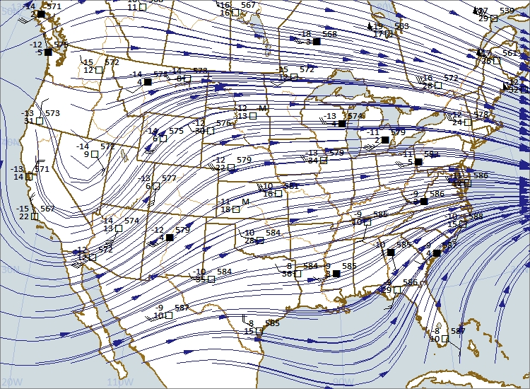
A wedge of very warm air is flooding the Plains into the Upper Midwest today. This is sending temperatures into the 90s to near 100 degrees with heat indices from near 100 to 110. The map below has a mix of data from the surface to about 5,000 feet above MSL (mean sea level). Notice the southwest flow (flow from SW to NE) from Texas to Minnesota. The air is also very moist. However, little in the way of thunderstorm activity is expected in the hot air mass because of its stability. The exception will be along the cool front from Minnesota to NE Colorado where there is enough lift to overcome a strong capping inversion aloft. Thunderstorms are also possible along the warm front in Minnesota and northern Wisconsin. 

Map plotted using Digital Atmosphere from www.weathergraphics.com. Map includes surface fronts, 850 mb heights, 850 mb temperatures, 850 mb mixing ratio, and 850 mb data plot.

Map plotted using Digital Atmosphere from www.weathergraphics.com. Map includes surface fronts, 850 mb heights, 850 mb temperatures, 850 mb mixing ratio, and 850 mb data plot.

The forecast map below is from the National Weather Service and is valid for June 29, 2018. Notice where severe storms are possible from Minnesota to South Dakota and Wyoming and portions of nearby states. The entire pattern will slip southeast on Saturday pushing into Iowa with heavy rain possible. By Sunday morning the cool front will extend from NW Wisconsin to Iowa and the Texas Panhandle. Thunderstorms are expected along the front with cooler air behind ending the hot spell.

national_forecast_6-29-18.jpg

A Near Hit

Close only counts in horseshoes. However, being close in the weather does have its advantages. For one, being close often avoids high winds and hail while still putting on quite a show.

Last evening a line of thunderstorms erupted south and southwest of Cedar Falls. Severe thunderstorm warnings were issued along the leading edge of the line. We were behind looking "in." Overhead were mammatus, the upside down lumpy clouds identified often with strong thunderstorms. (Keep in mind that storms with mammatus are not always severe and usually by the time they appear the threat is over.) In this case the threat was south and ongoing but where we were  it was a pleasant evening. 

The first photo below is looking east, the second is looking south, and the third is straight up. Notice how the appearance changes depending on where one looks. While the overall processes are similar across the sky each area had slightly different flow and processes occurring. Regardles, it was quite a show - all for free and all educational. The next step is wondering why!

Photo Copyright 2018 by Craig Johnson/Weather Briefing, LC

Photo Copyright 2018 by Craig Johnson/Weather Briefing, LC

Photo Copyright 2018 by Craig Johnson/Weather Briefing, LC

Photo Copyright 2018 by Craig Johnson/Weather Briefing, LC

Photo Copyright 2018 by Craig Johnson/Weather Briefing, LC
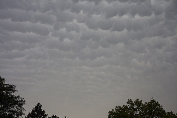
Photo Copyright 2018 by Craig Johnson/Weather Briefing, LC

Under the Anvil

Scattered thunderstorms moved across northeastern Iowa this evening. The following photos were taken under the back side of an anvil as it passed over Cedar Falls, Iowa. It was a small cell that produced only a trace of rain here. Stronger storms associated with severe thunderstorm warnings occurred to our northeast and southwest. The following photos show clouds that formed under the anvil. 

Altocumulus castellanus under the anvil slowly being revealed as light rain moves southeast away from the camera. Photo looking East.  Photo by Craig Johnson, copyright 2018.

Altocumulus castellanus under the anvil slowly being revealed as light rain moves southeast away from the camera. Photo looking East.  Photo by Craig Johnson, copyright 2018.

Altocumulus wave type clouds under the thunderstorm anvil. Photo looking SE. Photo by Craig Johnson. Copyright 2018.

Altocumulus wave type clouds under the thunderstorm anvil. Photo looking SE. Photo by Craig Johnson. Copyright 2018.

Mammatus clouds under the back of the anvil - looking W. Photo by Craig Johnson, copyright 2018.

Mammatus clouds under the back of the anvil - looking W. Photo by Craig Johnson, copyright 2018.

Surface weather map at 1900 CDT 5-25-2018 (0Z 5-26-2018).A Weak low pressure trof over north Central  Iowa helped trigger thunderstorms over northeast Iowa into Minnesota and Wisconsin. Servere weather was reported with some of the storms. The …

Surface weather map at 1900 CDT 5-25-2018 (0Z 5-26-2018).
A Weak low pressure trof over north Central  Iowa helped trigger thunderstorms over northeast Iowa into Minnesota and Wisconsin. Servere weather was reported with some of the storms. The map shows surface temperatures in the middle 80s ahead of the trof with dew points in the mid to upper 60s. The analysis shows the Theta-e field. Theta-e measures the total heat available in the atmosphere. It takes into account air temperature plus the heat that would be available if water vapor in the air condensed and released its heat (latent heat).The higher the theta-e temperature (in degrees K) the more available heat). 


The Old and the New

Wind power Then and Now: Photo Copyright 2018 Craig Johnson, Weather Briefing L..C. 

Wind power Then and Now: Photo Copyright 2018 Craig Johnson, Weather Briefing L..C. 

This photo taken in Adair County, Iowa contrasts old and new ways of capturing the power of the wind. The old wind mills were often used to pump water for livestock. The new ones are generating electricity. I'd estimate that the old wind mill here was about 20 feet tall. I am not sure of the height of the wind generators but they are often higher than 200 feet.

More Showers and Thunderstorms

500 mb chart at 00Z 5-22-2018 (7:00 p.m. CDT 5-21-2018). Chart plotted using Digital Atmosphere software from www.weathergraphics.com. 

500 mb chart at 00Z 5-22-2018 (7:00 p.m. CDT 5-21-2018). Chart plotted using Digital Atmosphere software from www.weathergraphics.com. 

Weak weather systems dominate most of the central and eastern United States as the next wave crosses the Inter-mountain Region. The storm (trough) aloft extends from Nevada south to just west of Baja Peninsula. The trough is located with the coldest air aloft. The wave dips south over California and turns northeast over Arizona, Utah, Colorado, and New Mexico. As the wave moves east it will increase the chances for more showers and thunderstorms over the central and southern Plains and then east to the prairie states.

USA SFC 01Z 5-21-2018.jpg

Surface Map - 0000Z 22 May 2018 (7:00 p.m. CDT 21 May 2018)  Map plotted by Digital Atmosphere available at weathergraphics.com

The two charts above show the relationship between the upper level winds at 18,000 feet and surface winds. A weak surface low is centered near Davenport, Iowa. Another weak area of low pressure is over eastern Colorado with another over Arizona. The Colorado and Arizona low pressures are located ahead of the trough at 500 millibars (18,000 feet) now crossing Nevada south to west of the Baja Peninsula. Look for the low pressure to become better organized east of the Rockies as trough (cold air aloft) emerges over the Plains during the next 24 hours. 

Peeking through the Fog

Photo by Craig Johnson, Cedar Falls, Iowa, 3-27-2018

Photo by Craig Johnson, Cedar Falls, Iowa, 3-27-2018

A thin layer of fog blotted out the Sun on this morning but it didn't last long. It was a radiation fog which is caused by low level cooling at ground level. The fog forms due to the cooling which condenses water vapor into tiny droplets of water. The fog formed after sunrise so it did not have time to deepen. As the Sun rose it heated the ground which heated the air where the fog formed and the fog dissipated. 

This is a different situation than the altostratus below. Altostratus is formed when condensation aloft is triggered by a layer of moist air rising in upward motion ahead of the storm system. The Sun does not burn off altostratus. The rising motion would need to be replaced by sinking motion - which warms the air causing the cloud to evaporation.