Clouds of the Day - A Stratus Kind of Day

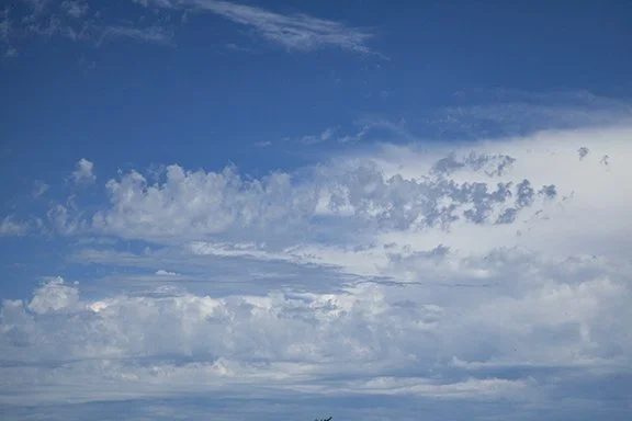
It is a stratus kind of day. After sharp lightning before midnight but only a trace of rain here and .04” at the Waterloo Airport only a couple of miles away, this is what the sky looked like at 9:30 AM. Stratus is a sheet-like cloud with a mostly uniform base. By this time the base was already showing a few rounded bottoms suggesting the formation clouds resembling cumulus. It is really a mixture of stratus and cumulus so the name is stratocumulus.

As temperatures warm during the day we can expect the cloud base to reveal breaks and the cloud base to rise into the mid-levels above 6,000 feet (2000 m).

As low level temperatures slowly warm mixing of the atmosphere begins to lower the relative humidity. At 1:00 PM we see the mid-level base of altostratus and altocumulus. There is even a hint of blue sky.

A close-up at 1:00 PM reveals the darker bases of altocumulus and a few lower cumulus. There are even a few ragged mid-level altocumulus floccus - tufts of wool. The mixing of the air allows drier air in the lower levels to mix with the air where the stratus has formed. The mixing lowers the relative humidity which breaks the cloud base open to reveal blue sky raise the cloud ceilings and change the cloud type.

Clouds of the Day - An Eastern Exit

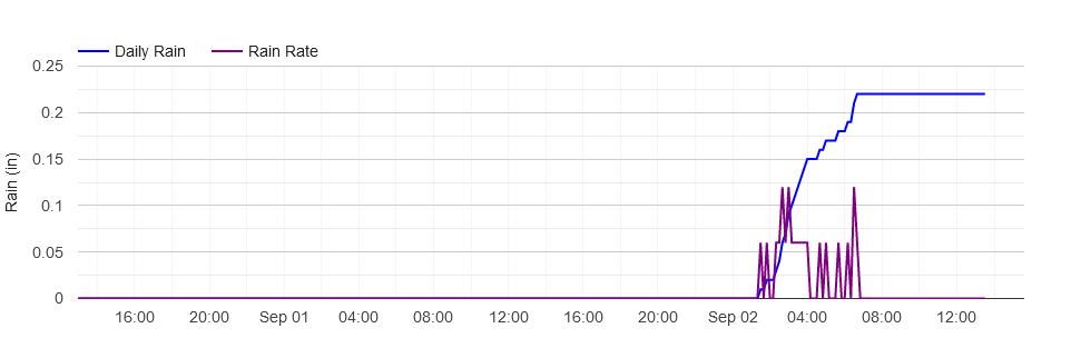
As the Sun was rising this morning clouds from nighttime showers were making an eastward exit. Our weather station rain guage measured .22 inches of rain overnight. The graph below shows when the rain began and ended. You can see the rain began after 1:00 AM and ended before 7:00 AM. The live chart on our website is interactive and allows you to see the time and amount of the rain. The accumulation of rain is the blue line and the purple is the rainfall rate per hour.

The wide angle photo shows faint crepuscular rays left of center. It also shows a variety of clouds on the backside of the exiting storm system.

The sky at the back of a storm system can be chaotic. There are several middle level cloud types in this photo. Photo by Craig Johnson at Cedar Falls, Iowa. Copyright 9-2-2022.

Close-up of the wide angle photo. Copyright Craig Johnson, Weather Briefing L.C. 9-2-2022.

A close-up of the clouds show some interesting patterns. In the center are altocumulus stratiformis lacunosus clouds. This is the complete scientific name including the - principle cloud type name , species, and variety names of the cloud.

Altocumulus is the principal cloud name, stratiformis is the species name, and lacunosus is the variety name. Altocumulus means high cumulus; it is higher than the regular low level cumulus cloud but below the cirrocumulus level. Stratiformis means the cloud is in a layer with stratus and cumulus characteristics, and lacunosus refers the the many holes in the cloud layer.

Toward the bottom there are altocumulus stratiformis clouds. They are lower than the layer highest clouds but higher than the lowest layer below. They cover the clouds above and have elements of small lumps mixed in a flat cloud layer.

Finally, the lowest clouds are altocumulus lenticularis - wave clouds at the bottom left and bottom right of the photo. The waves are rippling through the flow and are also visible at the far right of the wide angle photo.

Rollercoaster Ride

Altocumulus lenticularis, Cedar Falls, IA, 9-21-2016. Photo copyright by Craig Johnson, Weather Briefing, LC

If you look up and see clouds like these the air is rolling along like waves in the ocean. The waves are visible because clouds have formed at the top of each wave. Without the clouds the waves would be invisible. If we encounter the waves in an airplane the passengers may not appreciate the up and down motion. The waves are ripples in the air which occur when changes in wind speed and direction disturb different layers of air. These layers can move in an up and down motion for a few miles or hundreds of miles. When you see clouds like these there may be strong winds aloft.

Clouds of the Day - Distant Cumulonimbus

Cumulonimbus, 8-29-2022, Cedar Falls, Iowa. Photo copyright Craig Johnson, Weather Briefing, LC.

This thunderstorm formed south of Cedar Falls, Iowa last evening and moved east. The anvil is clearly visible at the top of the storm with winds aloft blowing ice crystals off the leading edge of the storm (right to left). Cumulus congestus are visible north of the storm (this side of the storm) building up into the main storm. The cumulus clouds are reflecting light from the Sun which is low on west northwest horizon. Altostratus clouds are also seen in thin dark lines. The patches are thin flat or slightly curved layers revealing waves in the air flowing around the thunderstorm. Cold dry air aloft is creating the clear blue sky above the storm. The sky was also clear above Cedar Falls.

Ordinary and Out of the Ordinary Clouds

Altocumulus, Cirrus spissatas, Cirrus fibratus, with fall streaks, Copyright 2020 by Craig Johnson, Weather Briefing, LC

This photo from late August 2020 shows includes ordinary and not so ordinary clouds. Cirrus spissatus are out of the ordinary but they occur often enough to be seen several times a year. Cirrus spissatus may appear grayish on the side facing away from the Sun. They often originate when a piece of thunderstorm anvil is separated from the top of the storm. As in this photo, cirrus spissatus may appear to be a middle level cloud because of the thickness and shape.

Cirrus are high clouds made mostly or entirely of ice crystals. They are found above 16,500 feet (5,000 meters). Most cirrus are thin or wispy and allow the Sun to shine through. Cirrus spissatus appear as dense clumps and often have ice crystals trailing the parent cloud (fall streaks). The spissatus and fall streaks in this photo are complex with a second layer of spissatus or a mid-level cumulus cloud variety in the form of a roll along the bottom of the photo. It is hard to determine from this distance. Cirrus spissatus often hides the Sun and is the only type of cirrus that will hide it. In the photo, the dense cloud in the center and left center of the photo is cirrus spissatus.

Cirrus fibratus are the hair-like filaments streaming off the spissatus in the upper center and are the thin finger-like fibrous patches at the right center.

Altocumulus are common mid-level clouds. They are in the upper right corner of this photo and are also seen with the blue sky background between the fall streaks (virga) in the center/left center. The altocumulus clouds are lower than the fall streaks (virga) in the foreground but appear to be higher because of their greater distance from the spissatus and the fall streaks being in the foreground.

Waves Upon Waves Upon Waves...

Photo copyrighted by Craig Johnson, Weather Briefing, LC and taken at Cedar Falls, Iowa

This dramatic sky was photographed on March 28, 2020 in Cedar Falls. This layer of altocumulus had waves coming from different directions. Gravity waves are caused by layers of air disturbed by the wind. The layers have different density and become disturbed when wind of different velocities interacts with the layers. Velocity is a combination of wind speed and wind direction. It is the difference in wind velocity (wind and speed) as air flows through adjacent layers that forms the waves. The stability of the air also determines the size and shape of the waves by setting up the vertical motion that ripples through the layer. The waves are similar to (but not exactly like) waves in water. Waves coming from different directions meet and cause complex patterns like are seen here.

Ducks in a Row

Photo copyright by Craig Johnson, Weather Briefing, LC at Cedar Falls, Iowa

The weather has its ‘ducks in a row’ in this photo. Four cumulus cells are visible here. Counting from left to right we see three main cells. The fourth is partially visible on the right edge of the photo. Each main cell has smaller areas of turbulence showing up as bulges protruding from the clouds.

In general, weather systems form on a continuous scale from very small, such as whirls the blow around the corners of buildings, to circulations that form on the scale (size) of clouds, thunderstorms, regional, national, continental to planetary systems. These circulations have similarities regardless of their size. Across the scale we can see the same shapes (circulations) interact. Some are more important in the smaller scales, such as tornadoes, while others are more important in larger scales, such as blizzards, but the designs are similar.

These cumulus clouds were part of a much larger weather system affecting the Upper Midwest. These cells formed in a line that extended for hundreds of miles. The entire system was organized from the largest to the smallest elements.

Pillows in the Sky: Or maybe much more…

Some clouds may not look very interesting. They are small and often associated with fair weather. Unlike the spectacular cumulonimbus (thunderstorm), small clouds do not stand out. But not so fast, small clouds are all part of the weather picture. Just like the big guys they have an important role to play.

The clouds in the photo to the left are the first signs something is happening. These clouds are plain cumulus. If you use your imagination, they may look like pillows; some could be fluffed up a little while others are just right. On a fair-weather day these clouds may not grow much larger. On other days these clouds could grow into a thunderstorm. Big things start in small packages.

Our weather uses many processes to control global temperatures. Clouds shield the Earth from sunlight during the day, keeping us cooler. Clouds help the Earth retain heat at night, keeping us warmer. When clouds form, heat of condensation is released into the atmosphere. The heat comes from the air that evaporates the water in the first place, from a local pond to hundreds or thousands of miles away. That is how heat is transported from one place to another without changing the temperature of the air along the way. It is called latent heat. The latent heat is released back into the air, warming the air slightly, when the water vapor condenses into back into water droplets or ice crystals.

The small clouds below may not look like much, but they are part of the Earth’s thermostat. And since water covers about 75% of the Earth it is the controlling factor in Earth’s global temperature control.

Photo copyright by Craig Johnson, Weather Briefing, LC., at Cedar Falls, IA

Ice Crystals Blowing in the Wind

Photo copyright by Craig Johnson Weather Briefing, LC. Photo at Cedar Falls, Iowa.

Cirrus clouds often create fall streaks containing ice crystals. These streaks can fill the sky with streamers like we see in this photo. The crystals are heavy enough to fall toward the ground, pulled by gravity that overcomes the slight upward motions that created the cirrus in the first place. These crystals do not reach the ground, however, if the crystals fall into lower clouds made of water droplets the crystals can seed the clouds with ice nuclei that encourage the growth of more ice or water droplets in the lower clouds. Those crystals or droplets may fall to earth as snow or rain.

Photo copyright by Craig Johnson, Weather Briefing, LC. at Cedar Falls, Iowa

This photo shows the fall streaks from a different angle. Ice crystals do not evaporate to become water vapor. Instead, the crystals will sublimate in dry air. That means they turn from a solid (ice) to water vapor directly without first become water droplets. Sublimation happens more slowly than evaporation so cirrus can be smeared long distances across the sky with strong winds aloft. That is what gives some cirrus to look of strands of hair that help give the cloud its name.

Water and Ice

Photo Copyright by Craig Johnson, Weather Briefing, LC. Cedar Falls, Iowa.

Did you know that even in summer most of us are never more than 2 to 3 miles away from snow and ice? In this photo a growing cumulus congestus is rising in the lower left while above it we see cirrus fibratus with tentacles stretched by the wind. The cumulus consists of tiny water droplets. The cirrus are made of ice crystals. The freezing line on a hot summer day is usually at an altitude between 12,000 to 15,000 feet high.

Cirrus on the Wings of the Wind

Cirrus flying along on the wings of high altitude winds created this picturesque scene in southwest Iowa during a hot July day in 2022. Notice the sweeping curls of ice crystals spreading into hair-like formations. Surface air temperatures were warmer than 90 F but at the cloud level readings were well below freezing. Cirrus are often seen in the sky either in lonely patches or are gradually thickening and lowering as a storm approaches. Scattered patches indicate fair weather but if the clouds gather look for a change as a storm system is likely in the area and approaching.

Storms come in different sizes and intensities. They may move fast or slow. They may be weak or intense. The rate at which clouds thicken and lower may indicate how fast a storm is approaching, how large it is, and available moisture and upward motion. Being weather wise means being in tune with how the weather is changing. Watching the sky provides a hint of what is happening.

Photo Copyright 2022 by Craig Johnson, Weather Briefing, LC. Looking east from Etna Ave in Adair, County, Iowa.

Upward Motion on Display

Photo at Cedar Falls, Iowa, Copyrighted 2022, BY Craig Johnson, Weather Briefing, LC.

For clouds to form there must be upward motion. If the motion is weak, say, a few inches per second, we will see layered clouds. Layered clouds are flat and without could not be described as being spectacular. Strong upward motion creates robust puffy clouds called cumulus. Cumulus come in many different sizes and shapes based on the strength of the updrafts.

The photo above reveals different varieties of cumulus clouds - all in the same photo! Closest to the camera are altocumulus floccus clouds. They are in the middle of the photo and look like tufts of wool. Further away across the lower part of the photo are thicker solid-looking cumulus mediocris and cumulus congestus formed from updrafts of 10 to 20 mph. Finally in the distance and visible behind all of the clouds in the upper right is the top of a cumulonimbus, the granddaddy of all clouds. Cumulonimbus are thunderstorms with updrafts from 20 to more than 60 mph. The top of the cloud is the thunderstorm anvil which can be from 30,000 to 60,000 above the Earth’s surface.

There is another cloud-type visible. Near the center/center-left of the photo is a layered cloud - altostratus. The thin layer indicates a weak layer of upward motion and moisture that is visible as a middle level cloud with weak upward vertical moton.

What Goes Up - Must Come Down

This is an example of what rain looks like as it falls from a nearby shower. This is a rain shaft, a column of raindrops falling to earth. The shower was located near Ackley, just north of Highway 20 in northern Iowa. The cloud base is plainly visible except where the rain is pouring out of the storm. The rain falling from a large cumulus congestus cloud had not reached the thunderstorm stage of development. The shower rained itself out before it could get larger.

Notice the small cumulus in the lower right portion of the photo and also in the lower left. They have much weaker updrafts but may become larger during the heat of the afternoon. The shower’s thick cloud base had distinct rolls and a sharp demarcation between the cloud and drier air below.

What goes up and must come down? Water falling from this shower evaporated at some unknown location and may have traveled hundreds of miles before rising into the cloud base and condensing into cloud droplets. When the droplets became large enough they were too heavy for the shower updraft to support - they fell to earth. The rain is the beginning of the end for this shower because the rain cools the air and stops the updraft. Without the inflow of warm moist air the shower loses its source of energy.

Other showers formed throughout the afternoon on this warm humid Iowa day and they all went through the same life cycle. It was the water that evaporated, became cloud droplets, rain drops, and fell back to earth. The water went up and then came back down.

Look Up and Notice the Waves

Photo taken at Cedar Falls, Iowa. Altocumulus stratiformis, Copyright 2022, Craig Johnson, Weather Briefing, LC

Our atmosphere is always in motion. If you fly regularly you know the air is not always smooth. Quite often there are bumps to contend with as air currents rise and fall or turn. The clouds above look like waves. The waves are similar to what we see on a lake or in a stream. Boats moving through waves bob up and down. So do aircraft when they encounter waves. It is called turbulence.

The clouds in the photo above are in the mid-levels between 6,500 and 20,000 feet above the ground. Waves on the left are distinct with definite areas of cloud with blue sky in between. To the right, the waves are embedded within a smoother cloud layer. Look for mid-level clouds to see if you can find wavy clouds.

These clouds are altocumulus (high cumulus). Cumulus are low clouds but mid-level cumulus are called high cumulus; or officially, altocumulus. And since these clouds are embedded within a layer of flat (stratus) clouds they are altocumulus stratiformis; mid-level cumulus in a stratus-like formation.

Be sure to look up every day, or several times a day if possible. The sky may change in a matter of minutes.

Altocumulus floccus or Tufts of Wool

Altocumulus floccus on 8-16-2016 over Cedar Falls, Iowa. Photo copyright 2016 by Craig Johnson

Can you name these clouds? Meteorologists name clouds based on their form and altitude, their size, shape, and their varieties based on how opaque or transparent they are and patterns they create.

There are three main cloud levels: low, middle, and high. Low clouds are called ‘low,’ middle clouds use the prefix ‘alto,’ which means high(er) than the low clouds, and the highest clouds are named cirrus or have the prefix ‘cirro.’

Because these clouds are in the middle level their name begins with the prefix ‘alto’ because they are inbetween the low clouds and highest clouds. Since they are heaped or puffy they use the principle cloud name ‘cumulus.’ Finally, these clouds look shredded, likes tufts of wool or cotton so they are described as floccus. So the name is:

Clouds of the Day - Mammatus

Mammatus Photo Copyright 2016 by Craig Johnson, Weather Briefing, LC

Mammatus clouds create dramatic patterns across the sky. Mammatus frighten many people because of their ominous look and relative rarity. From below the clouds appear dense but they are transparent when viewed from the cloud level. They are caused when heat released by condensation in thunderstorm updrafts reaches the stable layer of air at the top of the storm. The updraft slows and eventually sinks and rises and falls like a cork on waves in a lake. The up and down motion gradually dampens out.

The clouds are distinct and include waves and pouches that protrude down from the underside of the thunderstorm anvil. The clouds are not dangerous to us on the ground but the dramatic patterns of the clouds are often found with strong to severe thunderstorms. The coloration is due to light from the setting Sun shining on the underside of the clouds.

In this photo the mammatus are in the higher of the two cloud layers. The lower layer with the dark bases are altocumulus clouds. Mammatus are most often visible through the clear air on the back side of the anvil. They can appear elsewhere under the anvil but are often hidden by lower clouds and rain.

Sunset at Arches National Park Campground

Sunset at Arches National Park Campground

Photo copyright by Craig Johnson, WeatherBriefing.com

This photo was taken at sunset from the campground at Arches National Park near Moab, Utah. Temperatures had cooled considerably from mid-afternoon highs. The warmth of the day and a passing upper air disturbance had set off scattered thundershowers with gusty winds and a chilly rain. This photo shows the remnants of the thundershowers that by then had dissipated.

The setting Sun created a faint hint of yellow on the underside of altostratus clouds. On the left side of the photo fall streaks of rain not reaching the ground are seen hanging below the cloud base. Fall streaks are common in desert areas because dry low level air causes the rain to evaporate before it reaches the ground.

Fall Streaks reaching the ground at Arches National Park. Photo Copyright 2012 by Craig Johnson, Weather Briefing, LC

Deserts are dry for many reasons. In this case, Arches National Park is located in the interior of the North American Continent to the the east of several mountain ranges. As air flows over the continent from the Pacific Ocean its moisture is dropped on the windward side of the mountains. Rain shadows are found east of each mountain range. A rain shadow area is located downwind of mountain ranges on the lee side of the mountain ridges. In this case the west to east flow causes more precipitation to fall on the west side of the mountains than to the east. Successive north-south arranged mountain ridges force the air to rise and drop precipitation leaving little moisture for areas to the east.

Photo at Canyonlands National Park, Utah, copyright 2012 by Craig Johnson, Weather Briefing, LC

Notice the hint of green on top of the mesa in the lower left of the photo. This photo was taken in late September 2012 from Canyonlands National Park, Utah. There had been late summer thundershowers that encouraged new growth on top of the mesa. Vegetation in desert areas must take advantage of any rain it receives. The thick white clouds in the distance are late afternoon thundershowers. It often rains at the top of the mesa while the bottom of the canyon receives little rain because of evaporation of the raindrops. The clouds are moving right to left. Notice the shadows of clouds on the ground covering parts of the mesa and the walls of the canyon in the distance. As the shadows move there are small changes in temperature near the ground.

Wind Farms on Radar

The image below is from the NWS Radar at Des Moines, Iowa. There was

Radar image from Radarscope (National Weather Service Radar, NWS Des Moines, Iowa Forecast Office, 11:05 p.m. 8-1-2022)

The radar image above is from the National Weather Service Office in Des Moines, Iowa. The radar is showing a shower near the Iowa-Missouri border with its forecast path during the next hour. Rain is also indicated in the far northeast corner of Nebraska near Sioux City, Iowa (far upper left corner). The collections of yellow, orange, red and green pixels in southwest, central, and north central Iowa are wind farms. The greatest concentration of wind turbines in any county in Iowa is in Adair County, which is 2 counties west and one county south of Des Moines. The county has 535 turbines.

Clouds of the Day - July 1, 2022 - From Cumulus to Cirrus

Today was two days in one. It started with considerable cloudiness and two dense cloud layers; altocumulus underneath altostratus…

Photo by Craig Johnson, Weather Briefing, LC

Then came clearing and an unusual patch of cirrus. Cirrus often look like strands of hair. The cirrus in the photo below formed in an isolated patch.

Photo by Craig Johnson, Weather Briefing LC

Then came the traditional looking cirrus. The cirrus below are called cirrus uncinus, commonly called mares’ tails. Notice the hook shape with streams of ice crystals falling away from the leading edge of the cloud.

Photo by Craig Johnson, Weather Briefing, LC