Clouds of the Day with Fall Streaks - Friday, April 28, 2023

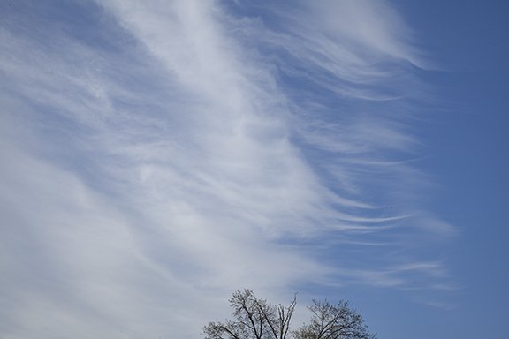
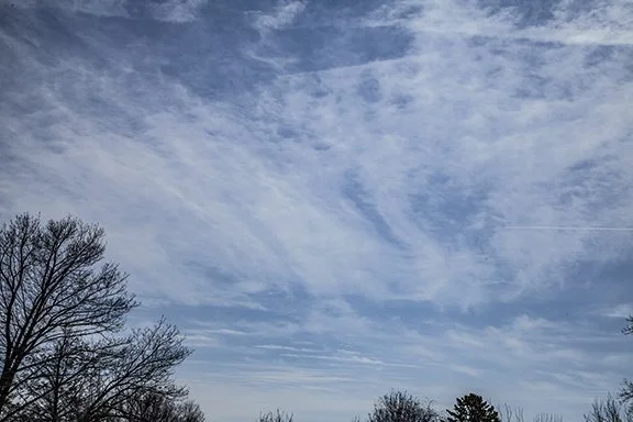
Fall Streaks occur when tiny super-cooled water droplets suddenly freeze and begin to fall from their parent cloud. The streaks look like thin strands of hair or wispy filaments. Photos this morning show hair-like fall streaks streaming from the parent cloud of tiny super-cooled droplets. Click on the button below to read an explanation from NESDIS.

Agitation of super-cooled water droplets may also cause them to flash-freeze. Flash freeze is the term for the instant freezing of super-cooled water droplets. Super-cooled droplets are water droplets below the freezing point. Super-cooled droplets occur in air that is void (or nearly void) of particulate matter. Particulate matter encourages condensation - makes it easier for cloud droplets to form than it otherwise would in clean air - which also makes it easier for rain or snow to form.

Morning Cirrus spissatus with fall streaks (looking south)

Close-up of fall streaks overhead

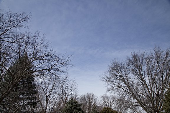
Later in the day: Cloud bases of developing showers approaching from the southwest

Clouds of the Day - April 27, 2023 - Cirrostratus and Cirrocumulus

Cirrostratus are not necessarily inspiring. This sheet-like cloud of ice crystals flows with high level wind streams above 16,000 feet. It is mostly found much higher where temperatures do not rise above freezing.

The three photos above illustrate Cirrostratus. The first photo shows only Cirrostratus. As one of the 10 principal cloud types, it creates an unmistakable milky sky. The lower photos include Cirrostratus but also Cirrocumulus and Cirrus fibratus. There are also two CONTRAILS (Condensation Trails) made of water vapor and ice in the the lower photos.

Cirrostratus are not beautiful like Cirrus uncinus and other Cirrus. Cirrostratus are not not always found in large sheets-like the clouds seen in the top and lower left photos. But Cirrostratus regularly visit the skies of the mid-latitude temperature zone. They can put on quite a display of beauty at sunrise and sunset when coloration from the rising and setting Sun bath them in red and yellow. It is then that they may be inspiring.

Cirrus in all its Glory

Cirrus clouds provide some of the most artistic patterns visible in the sky. Three examples below show how winds aloft can paint a variety of patterns at the same time. These photos were taken in a few minutes of each other and include Cirrus uncinus, cirrus fibratus, and cirrus floccus with fall streaks.

These clouds are formed by changes in wind direction and speed with height. It is the differences in wind direction and speed, also known as wind shear, that create the appearance seen in these photos. Cirrus contain ice crystals which can travel longer distances than water droplets, which evaporate easily in drier air. Ice crystals do not evaporate, they sublimate, which means the ice changes from solid crystals directly to water vapor. It takes longer for sublimation to occur. The cirrus with fall streaks (virga) take their shape by precipitating ice crystals which fall through slower moving air than the top of the cloud which creates the trailing streaks of crystals.

These photos were taken from Cedar Falls, Iowa on March 27, 2023.

Cirrus uncinus (hook-shaped), cirrus fibratus (wispy fibers), and cirrus floccus (clumps of Cirrus) with fall streaks

Clouds of the Day - Monday, April 3, 2023

All of these photos were taken within 5 minutes of each other in the early morning light.

Sunrise in the east.

Cumulus and Alto cumulus - looking West

Cumulus and Altocumulus - looking southwest

Cumulus, Altocumulus, and stratocumulus - Looking South Southeast

Altocumulus looking east northeast

Cumulus looking West Southwest

The day ends with sprinkles of rain followed by Altostratus

Clouds of the Day - Weather Story - March 31, 2023

An outbreak of severe weather is expected over the midsection of the United States today, as shown on the map below. This is part of a large synoptic scale storm system forecast to cross Iowa today. To the north and northeast of the low center heavy snow is expected while east and south rain and thunderstorms will occur.

This is the outlook for severe weather today from the Storm Prediction Center.

Here is a review of the clouds that formed today over Cedar Falls, Iowa. The day started with sunshine but as the day wore on altocumulus developed followed by thunderstorms.

This morning: Altocumulus stratiformis

This morning: This was the first sign of developing clouds.

This morning: Altocumulus clouds were next as upward motion in the mid-levels and weak instability created these mid-level clouds.

Late Afternoon: Base of developing thunderstorm

Late Afternoon: Base of developing thunderstorm

Late Afternoon: Base of developing thunderstorm. We had lightning and thunder

Storm Reports: Red indicates tornadoes

Clouds of the Day - Monday, March 27, 2023

One of the most unusual cloud formations is what you see below. This morning a patch of Cirrus uncinus produced these beautiful brushed patterns of ice crystals. Cirrus uncinus are hooked cirrus with ice crystals falling from a dense cloud. Uncinus are usually found without the cloud head which suggests the head has precipitated out leaving only the trail of falling ice crystals. The patterns illustrate nature’s beauty created by precipitation aloft. It’s to not be impressed!

Copyright 2023 by craig Johnson, Weather Briefing, LC.

Copyright 2023 by craig Johnson, Weather Briefing, LC.

Copyright 2023 by craig Johnson, Weather Briefing, LC.

Copyright 2023 by craig Johnson, Weather Briefing, LC.

Copyright 2023 by craig Johnson, Weather Briefing, LC.

Clouds of the Day - Saturday, March 25, 2023

Saturday, March 25, 2023 has been mostly sunny in Cedar Falls, Iowa with mainly cirrus and altocumulus clouds overhead. The day started with about 80% cloud cover but it is down to about 20% now with mostly thin cirrus.

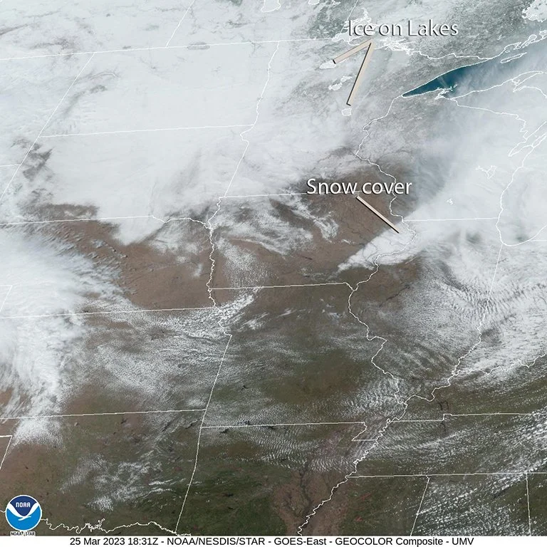
Low pressure centered over lower Michigan this morning is moving east. It left a strip of snow on the ground which is visible in the satellite image below. Cooler air is spreading south and southwest over the Northern Plains and Upper Midwest. This is evident in the temperatures which are in the 20s over North Dakota to the 30s in South Dakota, and 40s over Minnesota and Iowa. Decode the station model plots in those states to the the dew point and temperature readings. The winds on the station model plots are from the northwest through northeast at about 10-15 mph around the backside of the Michigan low pressure center.

Moderate to heavy snow is falling over the mountains of northern Wyoming and southern Montana and along the eastern upslope of the Rockies in Montana.

Map Plotted with Digital Atmosphere Software available from www.weathergraphics.com

Gulf Moisture is spreading northeast into the southeast U.S. with dew points in the 50s, 60s, and 70s.

I purposely used a moderately spaced distribution in the station model plot on this map to make it more readable than a denser plot. This would be a good map to practice your station decoding skills. Check out the station model plot tutorial part of our website for more details on the plots.

Clouds of the Day - Cedar Falls, Iowa

Photo copyright 2023 by Craig Johnson, Weather Briefing, LC.

This photo shows a large area of several cirrus cloud types this morning. The clouds were moving to the southeast from the upper right to the lower left. The clouds in the lower right half of the photo are mostly cirrus fibratus with more dense patches of cirrus mixed in. The striations are parallel to the wind direction.

In the upper left half there is more evidence of cross-banding of wave clouds perpendicular to the wind direction. There is also more instability present in three or four bands of cirrus in dense patches. These are cirrus spissatus with falling ice crystals trailing each dense cloud cell. This is precipitation aloft. There is a large area of fall streaks with intertwined fibers in the upper left area of the photo. There are CONTRAILS mixed in with the cirrus which are likely causing some of the the dense spissatus type cells to form.

This photo looks south.

Photo copyright 2023 by Craig Johnson, Weather Briefing, LC.

This is a look at the same part of the sky as the photo above but it is centered more to the upper right. The same discussion applies. Natural cirrus is mixed with clouds forming from the CONTRAILS. This creates a chaotic look to the clouds.

This photo looks south-southeast.

Photo copyright 2023 by Craig Johnson, Weather Briefing, LC.

Further northwest is a less developed area of cirrus. There are four well defined CONTRAILS in different stages of development. The youngest CONTRAIL is in the left center of the the photo. Each CONTRAIL to the upper right is progressively older than the one below it. It is easy to see how the CONTRAILs are changing with time by looking at the progression as the CONTRAILS age. This photo looks west.

The first three photos from the top were taken around 9:00 a.m. this morning. The photo above was taken about three hours later. It shows more CONTRAILS and the remnants of CONTRAILS. The natural cloud formations are the banded striations in the clouds on the far right center just above the trees and also the dense cloud patch along the bottom 1/4 of the photo. Everything else is related to CONTRAILS. By the way, CONTRAIL is an acronym for Condensation Trail which is condensing water vapor in the exhaust of aircraft flying around 20,000 to 40,000 feet above sea level.

Clouds of the Day - March 24, 2023

Cirrus spissatus is the only cirrus cloud type that can hide the Sun’s disk. All other cirrus are transparent to one degree or another. These clouds as thick clumps, as seen in this photo, and will often have ragged edges, also as seen in this photo.

This photo is looking to the northwest and the clouds are moving rapidly from the southwest to the northeast along the path of strong high altitude winds above 16, 000 feet.

The clouds below look like tufts of wool. Their name is altocumulus floccus. ‘Alto” means high and the prefix alto attached to a cloud type in this case means high cumulus - altocumulus. These clouds are found in the middle layers of the troposphere, between 6,500 feet and 16,500 feet, which makes them middle clouds. Clouds in the middle layer are either altocumulus or altostratus. Altocumulus are a puffy cloud type and altostratus are a flat cloud.

Clouds of the Day - March 23, 2023

There was plenty of sunshine today after .4 inches of snow overnight. The snow had a water content of .07 inches giving the snow a density of 15%. Drier air moved in after the snow ended, clearing out the low level cloudiness which make mid-level altostratus and cirrostratus above visible. During the afternoon a few small cumulus and cumulus fractus clouds formed as sunshine warmed the low levels. The warmer air melted the snow which added moisture to the air and supported the development of the cumulus type clouds.

The photo below reveals cirrus clouds across the top with bands of cirrostratus and altostratus across the bottom half. A few cumulus fractus clouds are visible in the middle right and lower right. Notice the small waves/ripples in the clouds in the center and center left. The ripples are caused by gravity waves in a stable layer of air at the level of the altostratus.

Photo copyrighted 2023 by Craig Johnson, Weather Briefing, LC

The next photo is a wider view of the photo above.

Photo copyrighted 2023 by Craig Johnson, Weather Briefing, LC

This photo is looking north into a layer of altostratus clouds that appears to be lowering near the bottom of the photo. One to five inches of snow fell to the north and especially northeast of our area from northeast Iowa into southwest Wisconsin. This clouds visible here were at the tail end of that snow band. Cloud bases were rising as drier air moved in behind the snow.

Photo copyrighted 2023 by Craig Johnson, Weather Briefing, LC

Clouds of the Day - March 22, 2023

The first day of spring in 2023 was on Monday, March 20th. Today the sky began to look like spring. Clouds in the Upper Midwest winter season sky are often low and gray. But warmer seasons bring clouds with more vertical development, punctuated by areas of blue sky. The clouds today included stratocumulus, cumulus, and altocumulus. The commonality is the cloud type - cumulus, a cloud with vertical development. Cumulus and stratocumulus are low level clouds with vertical development. Altocumulus are ‘high cumulus’, clouds with vertical development. They are found in the middle layer of the troposphere below the high layer where cirrus clouds reside. Today’s sky is bringing clouds of a new season - spring of 2023.

Photo copyright 2023 by Craig Johnson

Photo copyright 2023 by Craig Johnson

Photo copyright 2023 by Craig Johnson

Altocumulus Photo copyright 2023 by Craig Johnson

The day ended with broken high clouds in the southern sky with a patch of altostratus and altocumulus across the top.

Altostratus and altocumulus top right, Cirrus and thicker altostratus middle and bottom. Photo copyright by Craig Johnson

CONTRAILS and Clouds: 2-26-2023

Here is the forecast map for today from the Weather Prediction Center based on input from the Storm Prediction Center and National Hurricane Center. It is valid 7:00 a.m. this morning through 7:00 a.m. Monday, 27 February 2023. All three of those weather centers are associated with NOAA and are linked to from the Weather Briefing Homepage.

During the period snow and mixed precipitation is expected over northern New England, rain and freezing rain over the Upper Midwest with rain from the Mid-Mississippi and lower Missouri River valley to the Southern Plains where severe storms are possible. Much of the mountain west is expecting snow with rain in lower elevations with widespread rain expected over the far west including the West Coastal areas. Check your local NWS forecast which is also linked to on the Weather Briefing Homepage.
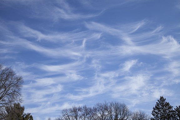
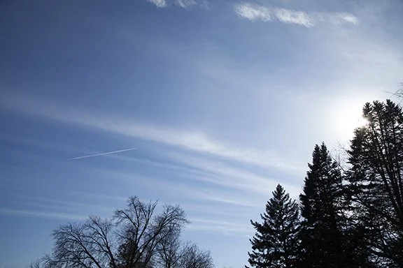
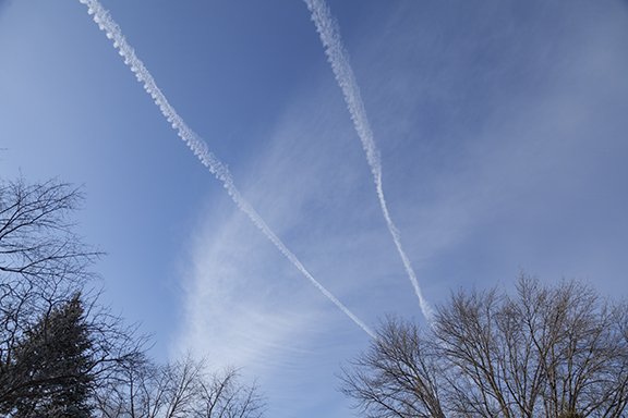
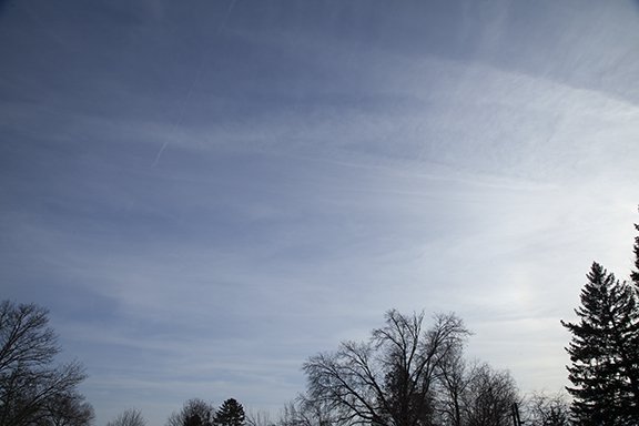
The photos below were taken this afternoon from Cedar Falls, Iowa. Rain is not expected here until later tonight so what you are seeing is rather deceiving. As the storm approaches clouds will thicken and lower but at the moment we are experiencing plenty of sunshine with our temperature near 50 degrees. See our weather station observation on the Weather Briefing homepage for the latest conditions.

This photo looks south. Cirrus clouds are streaming in bands from west to east. A CONTRAIL is visible left of center. It is water vapor condensing in the engine exhaust into the cold upper air. Winds aloft at the cirrus level are estimated to be around 50 - 55 mph and at the altitude of the aircraft probably closer to 75 mph from the west.

This is a closer view showing the CONTRAIL, Sun, and the Cirrus clouds. The cloud types are Cirrus fibratus and cirrostratus and the CONtRAIL.

Two parallel CONTRAILS are above the cirrus clouds. These cirrus are likely caused by the spreading out of an old CONTRAIL.

More contrails. This view is looking south and South southeast and were freshly formed. Another contrail is visible near the bottom of the photo. There is a closer view if you scroll down.

These contrails appear to be below the clouds. Other parts of the same CONTRAILS are above the clouds.

This patch of cloud appears to be made by the spreading of several CONTRAILS. Notice the fibraus cirrus in bands that are perpendicular to the thicker contrails. Air is moving parallel to the main cloud band and the ribs, which are perpendicular to the denser cloud band, is caused by descending air where the air is relatively clear and rising where the thicker bands (ribs) are visible.

The contrail across the bottom of the photo is breaking into a series of helmholz waves. You will get a better look in the photo below.

Notice the waves in the remnants of this CONTRAIL. Helmholz wave clouds are also known as fluctus. The cloud tops are leaning to the left because of stronger winds at the top than at the bottom of the cloud. This is called wind shear and occurs when winds increase with height in a stable layer of air. Stable air limits vertical motions in the layer. The winds are blowing from right to left. The waves make the air motion visible. It is likely that much of the sky is experiencing

Sparkling Ice

Ice on Trees following freezing rain and sleet; Cumulus clouds in the background

One quarter inch ice on trees; Cumulus fractus and cumulus in the background

After gray skies with freezing rain, sleet and snow yesterday, today sparkled. The branches on trees and bushes were coated with about .2” of ice and as skies cleared nearby trees showed off their sparkling coat like diamonds in the sunlight.

All photos copyright 2023 Weather Briefing, L.C.; Cumulus mediocris and Cumulus fractus in the background

Three Different Cloud Types at Once

Cirrostratus covered the sky in this photo. A weak upper level wave spread this patch of cloud made of ice crystals overhead. Later in the day mid-level clouds added to the show - as shown below.

Altocumulus floccus have moved over the right half of the photo. Altocumulus means high cumulus which form between 6,500 feet (2000 meters) and 20,000 feet (6,000 meters) above the surface. The clouds look like flocks of wool. A fading CONTRAIL is visible left of center along with Altostratus in the far left.

Winter Flocking - Hoar Frost

The combination of dense fog and sub-freezing temperatures is usually a good set-up for the formation of hoarfrost on trees and power lines. Hoarfrost is also known as white frost, crystalline frost, or just plain frost. It forms by sublimation which is the process where water vapor condenses as ice crystals. The trees in the photos below illustrate its beauty, especially with a blue sky background. Small diameter objects are ideal locations for the crystals to accumulate. Both the air and the objects must be below freezing. Cirrus and the spreading out of CONTRAILS (condensation trails) from aircraft formed the clouds in the background.

Winter Sky and Flocked Trees

Each of these photos feature Stratus clouds and trees decorated with newly fallen snow. Stratus are often featureless clouds with smooth bases that form during an invasion of colder air. These stratus formed near the top of a moist layer of air aloft in a region of upward motion. The upward motion developed in a northwesterly flow of air with broad cyclonic circulation over the Upper Midwest after a snowstorm.

Watch the sky change in 6 hours

Here is a sequence of photos that began in mid-morning and ended a couple of hours before sunset. The overcast at the end of the day was a layer of Altostratus clouds ahead of a weak upper level system aloft approaching from the northwest. The progression of lowering cloud ceilings (cloud bases) is caused by increasing moisture in the middle levels being lifted by the upward motion ahead of the weak storm system. The lifting raises the moisture to higher levels where the air pressure is lower. The moisture condenses into clouds which lower as the moist layer deepens and rising motion intensifies the condensation coverage.

Several clouds in the Cirrus family are seen in the top half of this photo. In the lower half a lower layer of altostratus is evident with small altocumulus.

Wispy Cirrus fibratus, Cirrostratus and high thicker Altostratus are seen in this photo. Fibratus means the cloud appears as filaments while cirrostratus are a thin smooth layer. The prominent cloud in the lower center has Cirrostratus and Cirrus fibratus characteristics. While we like to apply specific names to clouds nature forms clouds that may appear as combinations of cloud types. We normally look for what is most dominant or include all of the types in our descriptions if they are significant. Either way, the different types occur because different cloud processes and motions are creating the different shapes, sizes and cloud textures.

Compare this photo to the one below. The clouds look like waves washing up on a beach after the top of the wave broke. linear Thicker clouds alternate with thinner bands of cloud and blue sky. In The photo below small drifts resemble the wavy clouds. The waves are in bands determined by variations in wind speed that align perpendicular to the camera. Turbulent wind is crossing the snow in waves which deposit the ripples on the snow surface.

Drifted snow mimics wave patterns that are seen in clouds.

Here is another view of the wave forms in the clouds above. Notice the numerous CONTRAILS (Condensation Trails) as water vapor in the engine exhaust of aircraft condenses in the cloud streaks. In the upper left there is a shadow cast by the sun shining on a CONTRAIL. These clouds look like Cirrostratus and Cirrus fibratus. There is a patch of Cirrocumulus in the lower center and a band of thicker cirrostratus which look suspiciously like it could have began as a CONTRAIL.

This is altostratus with an indistinct cloud base. Look at the cloud base in the lower part of this photo and you will see the cloud base hanging as a thinning cloud bottom that gives way to a whiter sky near the horizon.

This is an Altostratus cloud that is transparent to the sun. There are two layers. The sunlight is diffused by the higher layer and the lower layer appears to be another altostratus layer (above 6,500 ft) but may have invaded the lower layer (below 6,500 ft) which would make it a stratus cloud. As the layer of upward vertical motion and moisture deepens with the approaching storm the cloud depth thickens. Eventually the upper and lower cloud layers merge as precipitation forms and the cloud name changes to Nimbostratus. Nimbostratus is a precipitating cloud. When precipitation stops the cloud with either be labelled stratus (a low cloud below 6,500 ft) or altostratus if its base is above 6,500 feet.